You are here: Home > Network List > MN - MEDNET Project Stations List
> Station BNI Bardonecchia, Italy > Earthquake Result Viewer
BNI Bardonecchia, Italy - Earthquake Result Viewer
| Earthquake location: |
Southern Alaska |
| Earthquake latitude/longitude: |
59.0/-155.1 |
| Earthquake time(UTC): |
2001/07/28 (209) 07:32:43 GMT |
| Earthquake Depth: |
131 km |
| Earthquake Magnitude: |
5.7 MB, 5.7 MS, 6.6 MW, 6.2 ME |
| Earthquake Catalog/Contributor: |
WHDF/NEIC |
|
| Network: |
MN MEDNET Project |
| Station: |
BNI Bardonecchia, Italy |
| Lat/Lon: |
45.05 N/6.68 E |
| Elevation: |
1395 m |
|
| Distance: |
75.2 deg |
| Az: |
13.242 deg |
| Baz: |
350.379 deg |
| Ray Param: |
0.05150337 |
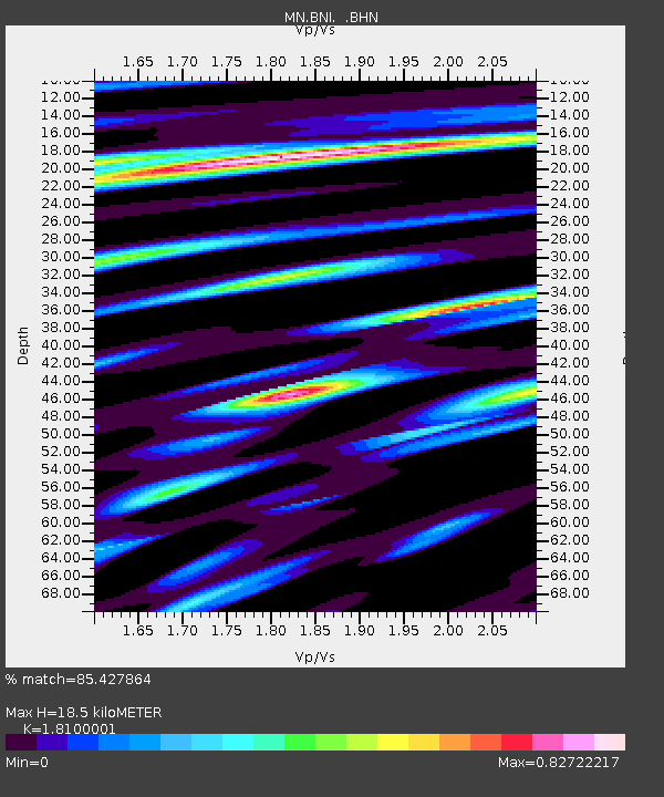
| Estimated Moho Depth: |
18.5 km |
| Estimated Crust Vp/Vs: |
1.81 |
| Assumed Crust Vp: |
6.416 km/s |
| Estimated Crust Vs: |
3.545 km/s |
| Estimated Crust Poisson's Ratio: |
0.28 |
|
| Radial Match: |
85.427864 % |
| Radial Bump: |
400 |
| Transverse Match: |
84.66421 % |
| Transverse Bump: |
400 |
| SOD ConfigId: |
3753 |
| Insert Time: |
2010-03-08 16:47:55.329 +0000 |
| GWidth: |
2.5 |
| Max Bumps: |
400 |
| Tol: |
0.001 |
|
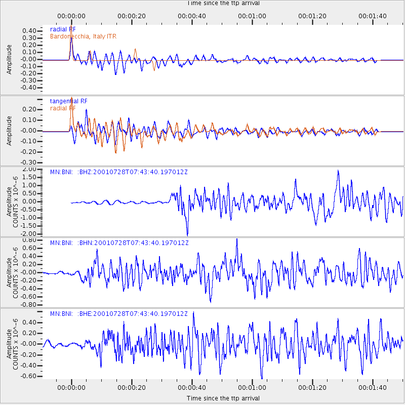
Signal To Noise
| Channel | StoN | STA | LTA |
| MN:BNI: :BHN:20010728T07:43:40.197012Z | 3.7212307 | 9.9340006E-8 | 2.669547E-8 |
| MN:BNI: :BHE:20010728T07:43:40.197012Z | 0.91746557 | 3.2267472E-8 | 3.5170228E-8 |
| MN:BNI: :BHZ:20010728T07:43:40.197012Z | 3.826175 | 2.510599E-7 | 6.561642E-8 |
| Arrivals |
| Ps | 2.4 SECOND |
| PpPs | 7.9 SECOND |
| PsPs/PpSs | 10 SECOND |


