You are here: Home > Network List > US - United States National Seismic Network Stations List
> Station MSO Missoula, Montana, USA > Earthquake Result Viewer
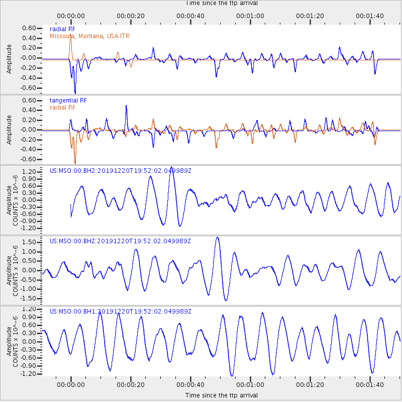
MSO Missoula, Montana, USA - Earthquake Result Viewer
*The percent match for this event was below the threshold and hence no stack was calculated.
| Earthquake location: |
Southeast Of Honshu, Japan |
| Earthquake latitude/longitude: |
32.9/142.8 |
| Earthquake time(UTC): |
2019/12/20 (354) 19:40:52 GMT |
| Earthquake Depth: |
10 km |
| Earthquake Magnitude: |
5.3 Mww |
| Earthquake Catalog/Contributor: |
NEIC PDE/us |
|
| Network: |
US United States National Seismic Network |
| Station: |
MSO Missoula, Montana, USA |
| Lat/Lon: |
46.83 N/113.94 W |
| Elevation: |
1264 m |
|
| Distance: |
74.9 deg |
| Az: |
43.788 deg |
| Baz: |
301.981 deg |
| Ray Param: |
$rayparam |
*The percent match for this event was below the threshold and hence was not used in the summary stack. |
|
| Radial Match: |
83.708565 % |
| Radial Bump: |
400 |
| Transverse Match: |
63.526333 % |
| Transverse Bump: |
255 |
| SOD ConfigId: |
20358551 |
| Insert Time: |
2020-01-03 19:53:48.021 +0000 |
| GWidth: |
2.5 |
| Max Bumps: |
400 |
| Tol: |
0.001 |
|
Signal To Noise
| Channel | StoN | STA | LTA |
| US:MSO:00:BHZ:20191220T19:52:02.049989Z | 0.57149315 | 1.9544366E-7 | 3.4198777E-7 |
| US:MSO:00:BH1:20191220T19:52:02.049989Z | 1.0116291 | 3.8878426E-7 | 3.84315E-7 |
| US:MSO:00:BH2:20191220T19:52:02.049989Z | 2.2828617 | 8.945931E-7 | 3.9187353E-7 |
| Arrivals |
| Ps | |
| PpPs | |
| PsPs/PpSs | |


