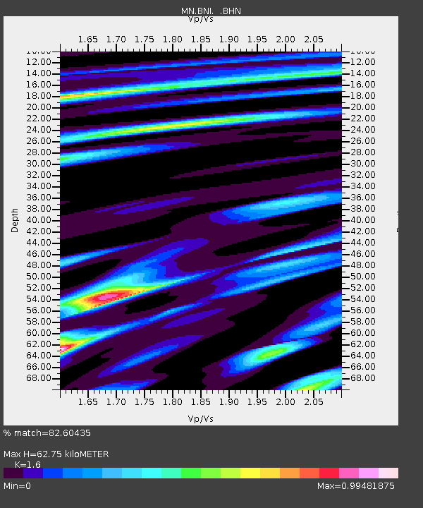
BNI Bardonecchia, Italy - Earthquake Result Viewer

Earthquake location: Southern Sumatra, Indonesia
Earthquake latitude/longitude: -0.5/99.3
Earthquake time(UTC): 1998/04/01 (091) 17:56:23 GMT
Earthquake Depth: 56 km
Earthquake Magnitude: 6.2 MB, 6.9 MS, 7.0 UNKNOWN, 6.6 ME
Earthquake Catalog/Contributor: WHDF/NEIC
Network: MN MEDNET Project
Station: BNI Bardonecchia, Italy
Lat/Lon: 45.05 N/6.68 E
Elevation: 1395 m
Distance: 92.2 deg
Az: 314.875 deg
Baz: 88.561 deg
Ray Param: 0.041472983
Estimated Moho Depth: 62.75 km
Estimated Crust Vp/Vs: 1.60
Assumed Crust Vp: 6.416 km/s
Estimated Crust Vs: 4.01 km/s
Estimated Crust Poisson's Ratio: 0.18
Radial Match: 82.60435 %
Radial Bump: 400
Transverse Match: 73.04403 %
Transverse Bump: 400
SOD ConfigId: 4480
Insert Time: 2010-03-08 16:48:08.539 +0000
GWidth: 2.5
Max Bumps: 400
Tol: 0.001

Signal To Noise

ChannelStoNSTALTA
MN:BNI: :BHN:19980401T18:08:55.700024Z3.52334749.800491E-72.7815852E-7
MN:BNI: :BHE:19980401T18:08:55.700024Z0.58157117.9954674E-81.3748047E-7
MN:BNI: :BHZ:19980401T18:08:55.700024Z0.87661232.8724372E-73.2767477E-7
Arrivals
Ps6.0 SECOND
PpPs25 SECOND
PsPs/PpSs31 SECOND