You are here: Home > Network List > IW - Intermountain West Stations List
> Station MOOW Moose Ponds, Wyoming, USA > Earthquake Result Viewer
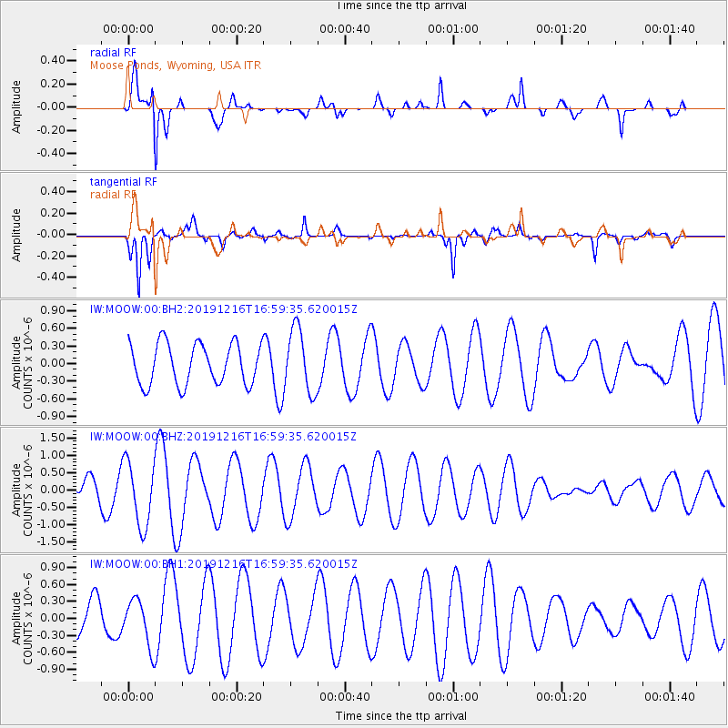
MOOW Moose Ponds, Wyoming, USA - Earthquake Result Viewer
*The percent match for this event was below the threshold and hence no stack was calculated.
| Earthquake location: |
Solomon Islands |
| Earthquake latitude/longitude: |
-8.4/159.0 |
| Earthquake time(UTC): |
2019/12/16 (350) 16:46:47 GMT |
| Earthquake Depth: |
71 km |
| Earthquake Magnitude: |
5.4 Mww |
| Earthquake Catalog/Contributor: |
NEIC PDE/us |
|
| Network: |
IW Intermountain West |
| Station: |
MOOW Moose Ponds, Wyoming, USA |
| Lat/Lon: |
43.75 N/110.74 W |
| Elevation: |
2128 m |
|
| Distance: |
96.0 deg |
| Az: |
46.772 deg |
| Baz: |
264.094 deg |
| Ray Param: |
$rayparam |
*The percent match for this event was below the threshold and hence was not used in the summary stack. |
|
| Radial Match: |
79.46933 % |
| Radial Bump: |
400 |
| Transverse Match: |
88.352 % |
| Transverse Bump: |
351 |
| SOD ConfigId: |
20358551 |
| Insert Time: |
2020-01-05 20:28:39.816 +0000 |
| GWidth: |
2.5 |
| Max Bumps: |
400 |
| Tol: |
0.001 |
|
Signal To Noise
| Channel | StoN | STA | LTA |
| IW:MOOW:00:BHZ:20191216T16:59:35.620015Z | 4.471928 | 9.258108E-7 | 2.0702723E-7 |
| IW:MOOW:00:BH1:20191216T16:59:35.620015Z | 2.1168203 | 4.176504E-7 | 1.9730084E-7 |
| IW:MOOW:00:BH2:20191216T16:59:35.620015Z | 1.5629926 | 5.405583E-7 | 3.458483E-7 |
| Arrivals |
| Ps | |
| PpPs | |
| PsPs/PpSs | |


