You are here: Home > Network List > TA - USArray Transportable Network (new EarthScope stations) Stations List
> Station D23K Nanushuk River, AK USA > Earthquake Result Viewer
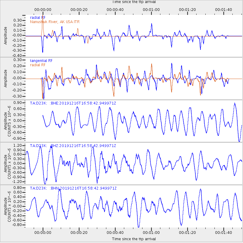
D23K Nanushuk River, AK USA - Earthquake Result Viewer
*The percent match for this event was below the threshold and hence no stack was calculated.
| Earthquake location: |
Solomon Islands |
| Earthquake latitude/longitude: |
-8.4/159.0 |
| Earthquake time(UTC): |
2019/12/16 (350) 16:46:47 GMT |
| Earthquake Depth: |
71 km |
| Earthquake Magnitude: |
5.4 Mww |
| Earthquake Catalog/Contributor: |
NEIC PDE/us |
|
| Network: |
TA USArray Transportable Network (new EarthScope stations) |
| Station: |
D23K Nanushuk River, AK USA |
| Lat/Lon: |
68.97 N/150.68 W |
| Elevation: |
406 m |
|
| Distance: |
84.7 deg |
| Az: |
16.208 deg |
| Baz: |
229.897 deg |
| Ray Param: |
$rayparam |
*The percent match for this event was below the threshold and hence was not used in the summary stack. |
|
| Radial Match: |
55.25156 % |
| Radial Bump: |
387 |
| Transverse Match: |
60.228046 % |
| Transverse Bump: |
400 |
| SOD ConfigId: |
20358551 |
| Insert Time: |
2020-01-05 20:29:52.970 +0000 |
| GWidth: |
2.5 |
| Max Bumps: |
400 |
| Tol: |
0.001 |
|
Signal To Noise
| Channel | StoN | STA | LTA |
| TA:D23K: :BHZ:20191216T16:58:42.949971Z | 2.0239651 | 9.180036E-7 | 4.5356688E-7 |
| TA:D23K: :BHN:20191216T16:58:42.949971Z | 0.5876958 | 1.4530069E-7 | 2.4723792E-7 |
| TA:D23K: :BHE:20191216T16:58:42.949971Z | 1.535499 | 4.7636146E-7 | 3.1023234E-7 |
| Arrivals |
| Ps | |
| PpPs | |
| PsPs/PpSs | |


