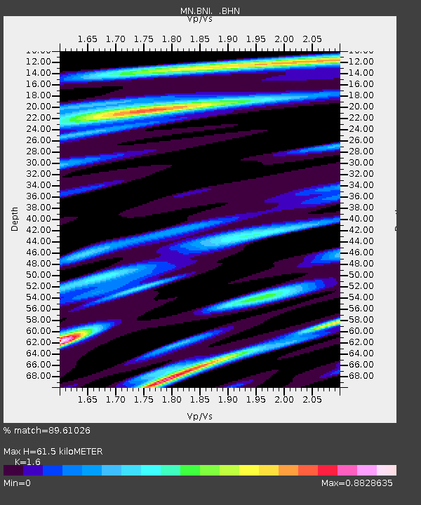
BNI Bardonecchia, Italy - Earthquake Result Viewer

Earthquake location: Andreanof Islands, Aleutian Is.
Earthquake latitude/longitude: 51.9/-179.4
Earthquake time(UTC): 2008/04/15 (106) 22:59:51 GMT
Earthquake Depth: 10 km
Earthquake Magnitude: 6.1 MB, 6.4 MS, 6.4 MW, 6.4 MW
Earthquake Catalog/Contributor: WHDF/NEIC
Network: MN MEDNET Project
Station: BNI Bardonecchia, Italy
Lat/Lon: 45.05 N/6.68 E
Elevation: 1395 m
Distance: 83.3 deg
Az: 355.696 deg
Baz: 3.765 deg
Ray Param: 0.046263296
Estimated Moho Depth: 61.5 km
Estimated Crust Vp/Vs: 1.60
Assumed Crust Vp: 6.416 km/s
Estimated Crust Vs: 4.01 km/s
Estimated Crust Poisson's Ratio: 0.18
Radial Match: 89.61026 %
Radial Bump: 400
Transverse Match: 86.40826 %
Transverse Bump: 400
SOD ConfigId: 2504
Insert Time: 2010-03-08 16:48:54.471 +0000
GWidth: 2.5
Max Bumps: 400
Tol: 0.001

Signal To Noise

ChannelStoNSTALTA
MN:BNI: :BHN:20080415T23:11:46.922998Z3.06038174.208511E-71.3751588E-7
MN:BNI: :BHE:20080415T23:11:46.922998Z2.0715582.1146627E-71.0208079E-7
MN:BNI: :BHZ:20080415T23:11:46.922998Z0.8904171.4745794E-71.6560548E-7
Arrivals
Ps5.9 SECOND
PpPs24 SECOND
PsPs/PpSs30 SECOND