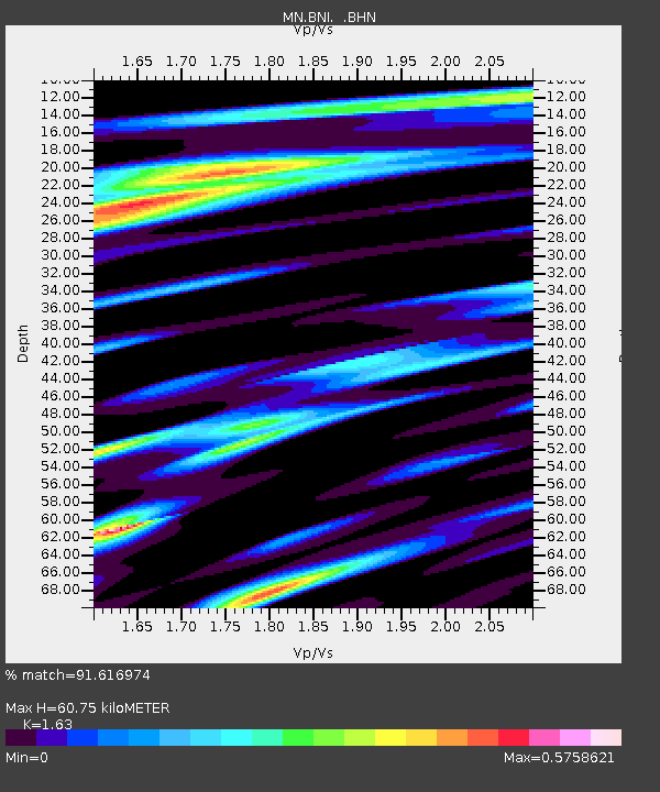
BNI Bardonecchia, Italy - Earthquake Result Viewer
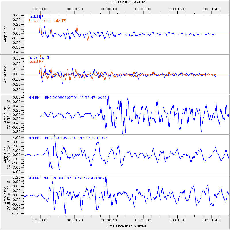
Earthquake location: Andreanof Islands, Aleutian Is.
Earthquake latitude/longitude: 51.9/-177.5
Earthquake time(UTC): 2008/05/02 (123) 01:33:37 GMT
Earthquake Depth: 14 km
Earthquake Magnitude: 6.3 MB, 6.8 MS, 6.6 MW, 6.6 MW
Earthquake Catalog/Contributor: WHDF/NEIC
Network: MN MEDNET Project
Station: BNI Bardonecchia, Italy
Lat/Lon: 45.05 N/6.68 E
Elevation: 1395 m
Distance: 83.4 deg
Az: 357.0 deg
Baz: 2.624 deg
Ray Param: 0.046211723
Estimated Moho Depth: 60.75 km
Estimated Crust Vp/Vs: 1.63
Assumed Crust Vp: 6.416 km/s
Estimated Crust Vs: 3.936 km/s
Estimated Crust Poisson's Ratio: 0.20
Radial Match: 91.616974 %
Radial Bump: 400
Transverse Match: 83.420334 %
Transverse Bump: 400
SOD ConfigId: 2504
Insert Time: 2010-03-08 16:48:57.498 +0000
GWidth: 2.5
Max Bumps: 400
Tol: 0.001

Signal To Noise

ChannelStoNSTALTA
MN:BNI: :BHN:20080502T01:45:32.474009Z6.3960557.034239E-71.0997777E-7
MN:BNI: :BHE:20080502T01:45:32.474009Z2.72510652.0200548E-77.4127556E-8
MN:BNI: :BHZ:20080502T01:45:32.474009Z0.871044757.20824E-88.2753964E-8
Arrivals
Ps6.1 SECOND
PpPs24 SECOND
PsPs/PpSs30 SECOND