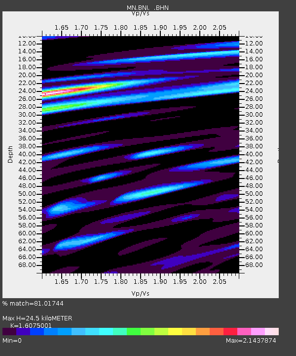
BNI Bardonecchia, Italy - Earthquake Result Viewer
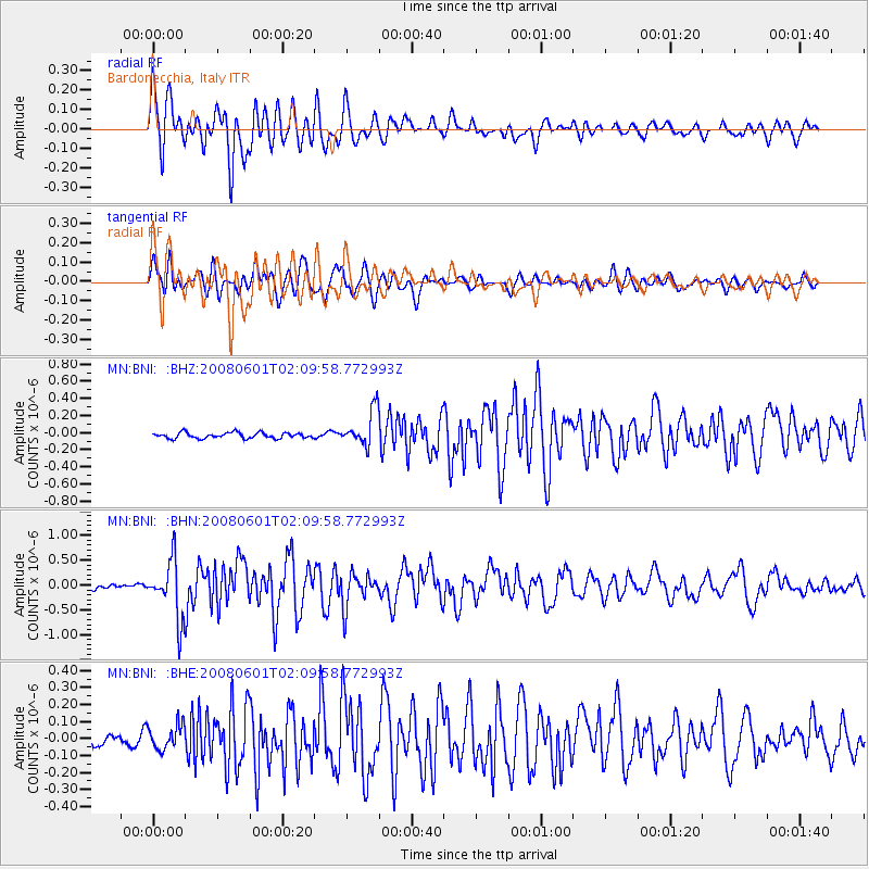
Earthquake location: Philippine Islands Region
Earthquake latitude/longitude: 20.1/121.4
Earthquake time(UTC): 2008/06/01 (153) 01:57:24 GMT
Earthquake Depth: 35 km
Earthquake Magnitude: 6.0 MB, 6.2 MS, 6.3 MW, 6.2 MW
Earthquake Catalog/Contributor: WHDF/NEIC
Network: MN MEDNET Project
Station: BNI Bardonecchia, Italy
Lat/Lon: 45.05 N/6.68 E
Elevation: 1395 m
Distance: 92.1 deg
Az: 319.874 deg
Baz: 58.687 deg
Ray Param: 0.041497465
Estimated Moho Depth: 24.5 km
Estimated Crust Vp/Vs: 1.61
Assumed Crust Vp: 6.416 km/s
Estimated Crust Vs: 3.991 km/s
Estimated Crust Poisson's Ratio: 0.18
Radial Match: 81.01744 %
Radial Bump: 400
Transverse Match: 82.29808 %
Transverse Bump: 400
SOD ConfigId: 2504
Insert Time: 2010-03-08 16:49:06.005 +0000
GWidth: 2.5
Max Bumps: 400
Tol: 0.001

Signal To Noise

ChannelStoNSTALTA
MN:BNI: :BHN:20080601T02:09:58.772993Z9.0405535.9449894E-76.575914E-8
MN:BNI: :BHE:20080601T02:09:58.772993Z1.85824767.1635526E-83.855004E-8
MN:BNI: :BHZ:20080601T02:09:58.772993Z6.24093062.0904093E-73.3495155E-8
Arrivals
Ps2.4 SECOND
PpPs9.7 SECOND
PsPs/PpSs12 SECOND