You are here: Home > Network List > TA - USArray Transportable Network (new EarthScope stations) Stations List
> Station E18K Tukpahlearik Creek, AK, USA > Earthquake Result Viewer
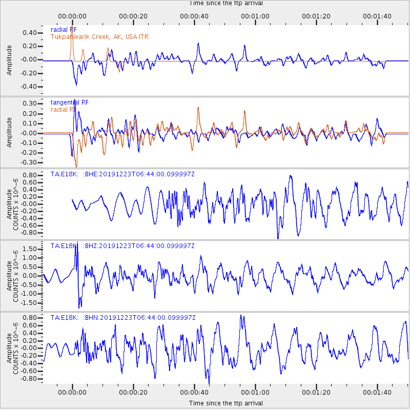
E18K Tukpahlearik Creek, AK, USA - Earthquake Result Viewer
*The percent match for this event was below the threshold and hence no stack was calculated.
| Earthquake location: |
W. Caroline Islands, Micronesia |
| Earthquake latitude/longitude: |
11.5/141.7 |
| Earthquake time(UTC): |
2019/12/23 (357) 06:33:40 GMT |
| Earthquake Depth: |
47 km |
| Earthquake Magnitude: |
5.8 Mww |
| Earthquake Catalog/Contributor: |
NEIC PDE/us |
|
| Network: |
TA USArray Transportable Network (new EarthScope stations) |
| Station: |
E18K Tukpahlearik Creek, AK, USA |
| Lat/Lon: |
67.42 N/160.60 W |
| Elevation: |
297 m |
|
| Distance: |
67.3 deg |
| Az: |
20.715 deg |
| Baz: |
243.866 deg |
| Ray Param: |
$rayparam |
*The percent match for this event was below the threshold and hence was not used in the summary stack. |
|
| Radial Match: |
65.25851 % |
| Radial Bump: |
400 |
| Transverse Match: |
69.03823 % |
| Transverse Bump: |
400 |
| SOD ConfigId: |
20358551 |
| Insert Time: |
2020-01-06 06:47:53.092 +0000 |
| GWidth: |
2.5 |
| Max Bumps: |
400 |
| Tol: |
0.001 |
|
Signal To Noise
| Channel | StoN | STA | LTA |
| TA:E18K: :BHZ:20191223T06:44:00.099997Z | 4.1972404 | 9.1514755E-7 | 2.1803554E-7 |
| TA:E18K: :BHN:20191223T06:44:00.099997Z | 1.2240418 | 2.1476443E-7 | 1.7545513E-7 |
| TA:E18K: :BHE:20191223T06:44:00.099997Z | 1.2789056 | 2.5725197E-7 | 2.0115006E-7 |
| Arrivals |
| Ps | |
| PpPs | |
| PsPs/PpSs | |


