You are here: Home > Network List > GO - National Seismic Network of Georgia Stations List
> Station ONI Oni > Earthquake Result Viewer
ONI Oni - Earthquake Result Viewer
| Earthquake location: |
Mindoro, Philippines |
| Earthquake latitude/longitude: |
13.7/120.9 |
| Earthquake time(UTC): |
2017/04/08 (098) 07:09:27 GMT |
| Earthquake Depth: |
43 km |
| Earthquake Magnitude: |
5.9 Mww |
| Earthquake Catalog/Contributor: |
NEIC PDE/us |
|
| Network: |
GO National Seismic Network of Georgia |
| Station: |
ONI Oni |
| Lat/Lon: |
42.59 N/43.45 E |
| Elevation: |
810 m |
|
| Distance: |
71.7 deg |
| Az: |
310.584 deg |
| Baz: |
88.068 deg |
| Ray Param: |
0.054100223 |
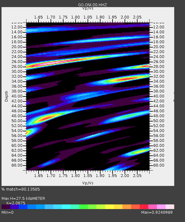
| Estimated Moho Depth: |
27.5 km |
| Estimated Crust Vp/Vs: |
2.10 |
| Assumed Crust Vp: |
6.247 km/s |
| Estimated Crust Vs: |
2.978 km/s |
| Estimated Crust Poisson's Ratio: |
0.35 |
|
| Radial Match: |
80.13585 % |
| Radial Bump: |
400 |
| Transverse Match: |
75.01274 % |
| Transverse Bump: |
400 |
| SOD ConfigId: |
2028011 |
| Insert Time: |
2017-04-22 07:12:42.612 +0000 |
| GWidth: |
2.5 |
| Max Bumps: |
400 |
| Tol: |
0.001 |
|

Signal To Noise
| Channel | StoN | STA | LTA |
| GO:ONI:00:HHZ:20170408T07:20:13.890024Z | 2.679498 | 2.9447506E-7 | 1.0989935E-7 |
| GO:ONI:00:HHN:20170408T07:20:13.890024Z | 1.100236 | 8.248342E-8 | 7.496884E-8 |
| GO:ONI:00:HHE:20170408T07:20:13.890024Z | 1.2507682 | 1.09275256E-7 | 8.736651E-8 |
| Arrivals |
| Ps | 5.0 SECOND |
| PpPs | 13 SECOND |
| PsPs/PpSs | 18 SECOND |


