You are here: Home > Network List > TA - USArray Transportable Network (new EarthScope stations) Stations List
> Station I30M Mount Dempster, Yukon, CAN > Earthquake Result Viewer
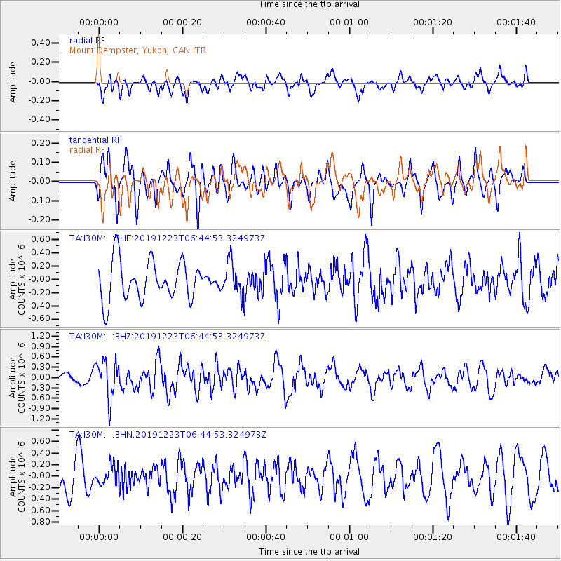
I30M Mount Dempster, Yukon, CAN - Earthquake Result Viewer
*The percent match for this event was below the threshold and hence no stack was calculated.
| Earthquake location: |
W. Caroline Islands, Micronesia |
| Earthquake latitude/longitude: |
11.5/141.7 |
| Earthquake time(UTC): |
2019/12/23 (357) 06:33:40 GMT |
| Earthquake Depth: |
47 km |
| Earthquake Magnitude: |
5.8 Mww |
| Earthquake Catalog/Contributor: |
NEIC PDE/us |
|
| Network: |
TA USArray Transportable Network (new EarthScope stations) |
| Station: |
I30M Mount Dempster, Yukon, CAN |
| Lat/Lon: |
65.22 N/136.38 W |
| Elevation: |
1399 m |
|
| Distance: |
76.2 deg |
| Az: |
25.442 deg |
| Baz: |
267.57 deg |
| Ray Param: |
$rayparam |
*The percent match for this event was below the threshold and hence was not used in the summary stack. |
|
| Radial Match: |
49.98903 % |
| Radial Bump: |
400 |
| Transverse Match: |
48.29087 % |
| Transverse Bump: |
365 |
| SOD ConfigId: |
20358551 |
| Insert Time: |
2020-01-06 06:48:10.145 +0000 |
| GWidth: |
2.5 |
| Max Bumps: |
400 |
| Tol: |
0.001 |
|
Signal To Noise
| Channel | StoN | STA | LTA |
| TA:I30M: :BHZ:20191223T06:44:53.324973Z | 2.3224797 | 5.369625E-7 | 2.3120225E-7 |
| TA:I30M: :BHN:20191223T06:44:53.324973Z | 0.4293959 | 1.6959167E-7 | 3.949541E-7 |
| TA:I30M: :BHE:20191223T06:44:53.324973Z | 0.8080115 | 2.3986846E-7 | 2.968627E-7 |
| Arrivals |
| Ps | |
| PpPs | |
| PsPs/PpSs | |


