You are here: Home > Network List > MN - MEDNET Project Stations List
> Station BNI Bardonecchia, Italy > Earthquake Result Viewer
BNI Bardonecchia, Italy - Earthquake Result Viewer
| Earthquake location: |
Northern Mid-Atlantic Ridge |
| Earthquake latitude/longitude: |
23.8/-45.4 |
| Earthquake time(UTC): |
1991/06/10 (161) 17:35:49 GMT |
| Earthquake Depth: |
10 km |
| Earthquake Magnitude: |
6.2 MB, 6.4 MS |
| Earthquake Catalog/Contributor: |
WHDF/NEIC |
|
| Network: |
MN MEDNET Project |
| Station: |
BNI Bardonecchia, Italy |
| Lat/Lon: |
45.05 N/6.68 E |
| Elevation: |
1395 m |
|
| Distance: |
47.0 deg |
| Az: |
49.833 deg |
| Baz: |
261.052 deg |
| Ray Param: |
0.07028508 |
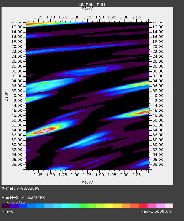
| Estimated Moho Depth: |
54.0 km |
| Estimated Crust Vp/Vs: |
1.67 |
| Assumed Crust Vp: |
6.416 km/s |
| Estimated Crust Vs: |
3.836 km/s |
| Estimated Crust Poisson's Ratio: |
0.22 |
|
| Radial Match: |
83.88099 % |
| Radial Bump: |
400 |
| Transverse Match: |
75.87689 % |
| Transverse Bump: |
400 |
| SOD ConfigId: |
16938 |
| Insert Time: |
2010-03-08 16:49:47.327 +0000 |
| GWidth: |
2.5 |
| Max Bumps: |
400 |
| Tol: |
0.001 |
|

Signal To Noise
| Channel | StoN | STA | LTA |
| MN:BNI: :BHN:19910610T17:43:49.694006Z | 0.68353623 | 6.740961E-8 | 9.8618926E-8 |
| MN:BNI: :BHE:19910610T17:43:49.694006Z | 6.474883 | 8.0154746E-7 | 1.2379336E-7 |
| MN:BNI: :BHZ:19910610T17:43:49.694006Z | 11.928204 | 1.7700831E-6 | 1.4839478E-7 |
| Arrivals |
| Ps | 6.0 SECOND |
| PpPs | 21 SECOND |
| PsPs/PpSs | 27 SECOND |


