You are here: Home > Network List > MN - MEDNET Project Stations List
> Station BNI Bardonecchia, Italy > Earthquake Result Viewer
BNI Bardonecchia, Italy - Earthquake Result Viewer
| Earthquake location: |
Southern Sumatra, Indonesia |
| Earthquake latitude/longitude: |
-1.1/99.9 |
| Earthquake time(UTC): |
1991/07/02 (183) 05:14:30 GMT |
| Earthquake Depth: |
54 km |
| Earthquake Magnitude: |
5.9 MB, 6.2 UNKNOWN |
| Earthquake Catalog/Contributor: |
WHDF/NEIC |
|
| Network: |
MN MEDNET Project |
| Station: |
BNI Bardonecchia, Italy |
| Lat/Lon: |
45.05 N/6.68 E |
| Elevation: |
1395 m |
|
| Distance: |
93.1 deg |
| Az: |
314.868 deg |
| Baz: |
88.506 deg |
| Ray Param: |
0.041306887 |
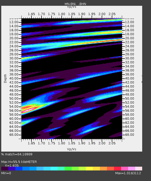
| Estimated Moho Depth: |
55.5 km |
| Estimated Crust Vp/Vs: |
1.63 |
| Assumed Crust Vp: |
6.416 km/s |
| Estimated Crust Vs: |
3.924 km/s |
| Estimated Crust Poisson's Ratio: |
0.20 |
|
| Radial Match: |
84.18989 % |
| Radial Bump: |
400 |
| Transverse Match: |
73.97854 % |
| Transverse Bump: |
400 |
| SOD ConfigId: |
16938 |
| Insert Time: |
2010-03-08 16:49:50.494 +0000 |
| GWidth: |
2.5 |
| Max Bumps: |
400 |
| Tol: |
0.001 |
|

Signal To Noise
| Channel | StoN | STA | LTA |
| MN:BNI: :BHN:19910702T05:27:06.843005Z | 0.74890256 | 3.476772E-8 | 4.642489E-8 |
| MN:BNI: :BHE:19910702T05:27:06.843005Z | 2.8538592 | 1.07132195E-7 | 3.753941E-8 |
| MN:BNI: :BHZ:19910702T05:27:06.843005Z | 7.4283876 | 3.9771956E-7 | 5.3540496E-8 |
| Arrivals |
| Ps | 5.6 SECOND |
| PpPs | 22 SECOND |
| PsPs/PpSs | 28 SECOND |


