You are here: Home > Network List > MN - MEDNET Project Stations List
> Station BNI Bardonecchia, Italy > Earthquake Result Viewer
BNI Bardonecchia, Italy - Earthquake Result Viewer
| Earthquake location: |
Lake Tanganyika Region |
| Earthquake latitude/longitude: |
-6.2/29.8 |
| Earthquake time(UTC): |
2005/12/05 (339) 12:19:56 GMT |
| Earthquake Depth: |
22 km |
| Earthquake Magnitude: |
6.4 MB, 7.2 MS, 6.8 MW, 6.7 MW |
| Earthquake Catalog/Contributor: |
WHDF/NEIC |
|
| Network: |
MN MEDNET Project |
| Station: |
BNI Bardonecchia, Italy |
| Lat/Lon: |
45.05 N/6.68 E |
| Elevation: |
1395 m |
|
| Distance: |
55.1 deg |
| Az: |
340.137 deg |
| Baz: |
151.54 deg |
| Ray Param: |
0.06497986 |
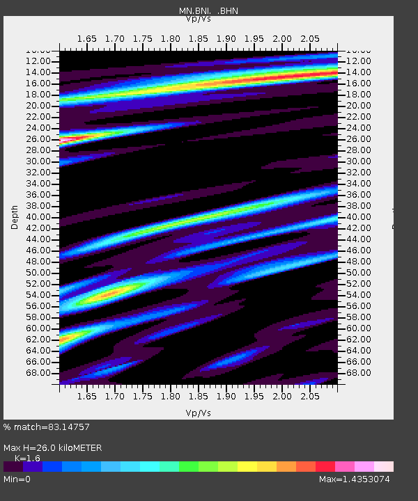
| Estimated Moho Depth: |
26.0 km |
| Estimated Crust Vp/Vs: |
1.60 |
| Assumed Crust Vp: |
6.416 km/s |
| Estimated Crust Vs: |
4.01 km/s |
| Estimated Crust Poisson's Ratio: |
0.18 |
|
| Radial Match: |
83.14757 % |
| Radial Bump: |
400 |
| Transverse Match: |
65.95187 % |
| Transverse Bump: |
400 |
| SOD ConfigId: |
2564 |
| Insert Time: |
2010-03-08 16:50:07.482 +0000 |
| GWidth: |
2.5 |
| Max Bumps: |
400 |
| Tol: |
0.001 |
|

Signal To Noise
| Channel | StoN | STA | LTA |
| MN:BNI: :BHN:20051205T12:28:56.109014Z | 5.4157887 | 1.3698401E-6 | 2.5293454E-7 |
| MN:BNI: :BHE:20051205T12:28:56.109014Z | 3.1023815 | 8.848587E-7 | 2.852192E-7 |
| MN:BNI: :BHZ:20051205T12:28:56.109014Z | 7.202153 | 3.3414372E-6 | 4.6394973E-7 |
| Arrivals |
| Ps | 2.6 SECOND |
| PpPs | 9.9 SECOND |
| PsPs/PpSs | 13 SECOND |


