You are here: Home > Network List > MN - MEDNET Project Stations List
> Station BNI Bardonecchia, Italy > Earthquake Result Viewer
BNI Bardonecchia, Italy - Earthquake Result Viewer
| Earthquake location: |
North Of Honduras |
| Earthquake latitude/longitude: |
16.7/-86.2 |
| Earthquake time(UTC): |
2009/05/28 (148) 08:24:45 GMT |
| Earthquake Depth: |
10 km |
| Earthquake Magnitude: |
6.7 MB, 7.2 MS, 7.3 MW, 7.3 MW |
| Earthquake Catalog/Contributor: |
WHDF/NEIC |
|
| Network: |
MN MEDNET Project |
| Station: |
BNI Bardonecchia, Italy |
| Lat/Lon: |
45.05 N/6.68 E |
| Elevation: |
1395 m |
|
| Distance: |
80.4 deg |
| Az: |
45.892 deg |
| Baz: |
283.909 deg |
| Ray Param: |
0.048319086 |
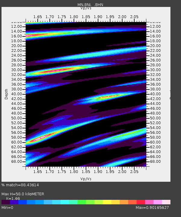
| Estimated Moho Depth: |
58.0 km |
| Estimated Crust Vp/Vs: |
1.66 |
| Assumed Crust Vp: |
6.416 km/s |
| Estimated Crust Vs: |
3.865 km/s |
| Estimated Crust Poisson's Ratio: |
0.22 |
|
| Radial Match: |
88.43614 % |
| Radial Bump: |
400 |
| Transverse Match: |
85.53509 % |
| Transverse Bump: |
400 |
| SOD ConfigId: |
2648 |
| Insert Time: |
2010-03-08 16:50:43.430 +0000 |
| GWidth: |
2.5 |
| Max Bumps: |
400 |
| Tol: |
0.001 |
|
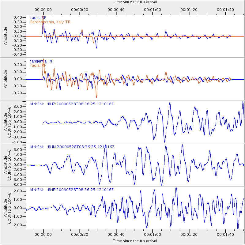
Signal To Noise
| Channel | StoN | STA | LTA |
| MN:BNI: :BHN:20090528T08:36:25.121016Z | 10.793497 | 1.3747884E-6 | 1.2737192E-7 |
| MN:BNI: :BHE:20090528T08:36:25.121016Z | 0.84003305 | 8.4680025E-8 | 1.00805586E-7 |
| MN:BNI: :BHZ:20090528T08:36:25.121016Z | 4.3809123 | 4.3753195E-7 | 9.987233E-8 |
| Arrivals |
| Ps | 6.1 SECOND |
| PpPs | 23 SECOND |
| PsPs/PpSs | 29 SECOND |


