You are here: Home > Network List > US - United States National Seismic Network Stations List
> Station DGMT Dagmar, Montana, USA > Earthquake Result Viewer
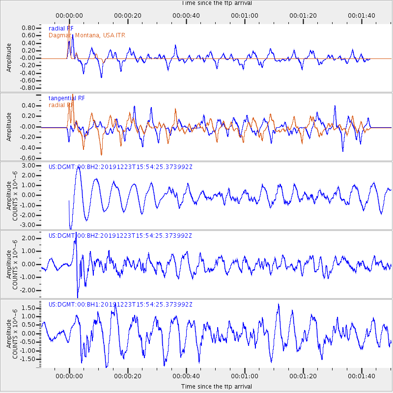
DGMT Dagmar, Montana, USA - Earthquake Result Viewer
*The percent match for this event was below the threshold and hence no stack was calculated.
| Earthquake location: |
Off Coast Of Chiapas, Mexico |
| Earthquake latitude/longitude: |
13.8/-92.8 |
| Earthquake time(UTC): |
2019/12/23 (357) 15:47:56 GMT |
| Earthquake Depth: |
10 km |
| Earthquake Magnitude: |
5.8 Mww |
| Earthquake Catalog/Contributor: |
NEIC PDE/us |
|
| Network: |
US United States National Seismic Network |
| Station: |
DGMT Dagmar, Montana, USA |
| Lat/Lon: |
48.47 N/104.20 W |
| Elevation: |
0.0 m |
|
| Distance: |
35.8 deg |
| Az: |
347.009 deg |
| Baz: |
160.843 deg |
| Ray Param: |
$rayparam |
*The percent match for this event was below the threshold and hence was not used in the summary stack. |
|
| Radial Match: |
74.078636 % |
| Radial Bump: |
400 |
| Transverse Match: |
38.032604 % |
| Transverse Bump: |
344 |
| SOD ConfigId: |
20358551 |
| Insert Time: |
2020-01-06 16:03:02.233 +0000 |
| GWidth: |
2.5 |
| Max Bumps: |
400 |
| Tol: |
0.001 |
|
Signal To Noise
| Channel | StoN | STA | LTA |
| US:DGMT:00:BHZ:20191223T15:54:25.373992Z | 4.7029257 | 1.1534742E-6 | 2.4526736E-7 |
| US:DGMT:00:BH1:20191223T15:54:25.373992Z | 2.0817196 | 7.625697E-7 | 3.6631718E-7 |
| US:DGMT:00:BH2:20191223T15:54:25.373992Z | 0.41076645 | 6.055741E-7 | 1.474254E-6 |
| Arrivals |
| Ps | |
| PpPs | |
| PsPs/PpSs | |


