You are here: Home > Network List > US - United States National Seismic Network Stations List
> Station LAO LASA Array, Montana, USA > Earthquake Result Viewer
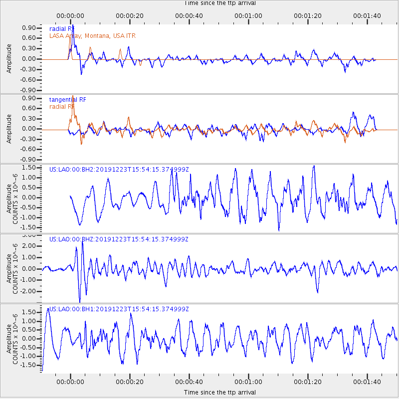
LAO LASA Array, Montana, USA - Earthquake Result Viewer
*The percent match for this event was below the threshold and hence no stack was calculated.
| Earthquake location: |
Off Coast Of Chiapas, Mexico |
| Earthquake latitude/longitude: |
13.8/-92.8 |
| Earthquake time(UTC): |
2019/12/23 (357) 15:47:56 GMT |
| Earthquake Depth: |
10 km |
| Earthquake Magnitude: |
5.8 Mww |
| Earthquake Catalog/Contributor: |
NEIC PDE/us |
|
| Network: |
US United States National Seismic Network |
| Station: |
LAO LASA Array, Montana, USA |
| Lat/Lon: |
46.69 N/106.22 W |
| Elevation: |
902 m |
|
| Distance: |
34.7 deg |
| Az: |
343.671 deg |
| Baz: |
156.624 deg |
| Ray Param: |
$rayparam |
*The percent match for this event was below the threshold and hence was not used in the summary stack. |
|
| Radial Match: |
57.51071 % |
| Radial Bump: |
319 |
| Transverse Match: |
45.47129 % |
| Transverse Bump: |
337 |
| SOD ConfigId: |
20358551 |
| Insert Time: |
2020-01-06 16:03:07.874 +0000 |
| GWidth: |
2.5 |
| Max Bumps: |
400 |
| Tol: |
0.001 |
|
Signal To Noise
| Channel | StoN | STA | LTA |
| US:LAO:00:BHZ:20191223T15:54:15.374999Z | 5.4133143 | 1.2706208E-6 | 2.3472143E-7 |
| US:LAO:00:BH1:20191223T15:54:15.374999Z | 0.29197612 | 3.1905674E-7 | 1.0927495E-6 |
| US:LAO:00:BH2:20191223T15:54:15.374999Z | 1.296248 | 6.79364E-7 | 5.2410036E-7 |
| Arrivals |
| Ps | |
| PpPs | |
| PsPs/PpSs | |


