You are here: Home > Network List > PF - Volcanologic Network of Piton de Fournaise-OVPF Stations List
> Station HIM cratere Himiltrude > Earthquake Result Viewer
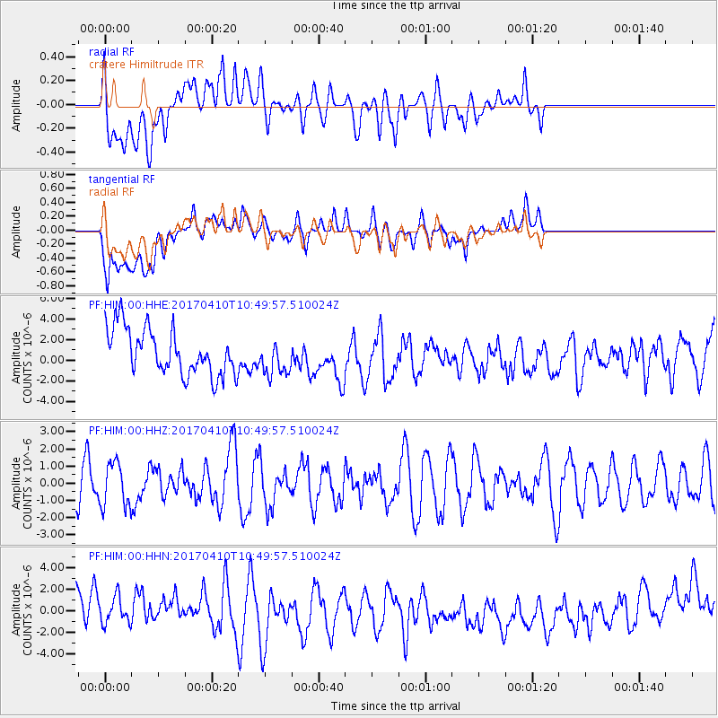
HIM cratere Himiltrude - Earthquake Result Viewer
*The percent match for this event was below the threshold and hence no stack was calculated.
| Earthquake location: |
Philippine Islands Region |
| Earthquake latitude/longitude: |
5.7/127.2 |
| Earthquake time(UTC): |
2017/04/10 (100) 10:38:48 GMT |
| Earthquake Depth: |
13 km |
| Earthquake Magnitude: |
5.8 Mww |
| Earthquake Catalog/Contributor: |
NEIC PDE/us |
|
| Network: |
PF Volcanologic Network of Piton de Fournaise-OVPF |
| Station: |
HIM cratere Himiltrude |
| Lat/Lon: |
21.21 S/55.72 E |
| Elevation: |
1958 m |
|
| Distance: |
75.0 deg |
| Az: |
246.367 deg |
| Baz: |
77.708 deg |
| Ray Param: |
$rayparam |
*The percent match for this event was below the threshold and hence was not used in the summary stack. |
|
| Radial Match: |
40.946514 % |
| Radial Bump: |
400 |
| Transverse Match: |
35.135498 % |
| Transverse Bump: |
400 |
| SOD ConfigId: |
2028011 |
| Insert Time: |
2017-04-24 10:41:07.508 +0000 |
| GWidth: |
2.5 |
| Max Bumps: |
400 |
| Tol: |
0.001 |
|
Signal To Noise
| Channel | StoN | STA | LTA |
| PF:HIM:00:HHZ:20170410T10:49:57.510024Z | 1.0168184 | 1.2704737E-6 | 1.2494598E-6 |
| PF:HIM:00:HHN:20170410T10:49:57.510024Z | 0.6153027 | 1.5192284E-6 | 2.4690746E-6 |
| PF:HIM:00:HHE:20170410T10:49:57.510024Z | 0.76930845 | 1.7191601E-6 | 2.2346824E-6 |
| Arrivals |
| Ps | |
| PpPs | |
| PsPs/PpSs | |


