You are here: Home > Network List > PF - Volcanologic Network of Piton de Fournaise-OVPF Stations List
> Station FRE Station Sismologique des Fonds de la Riviere de l'Est > Earthquake Result Viewer
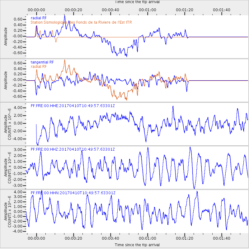
FRE Station Sismologique des Fonds de la Riviere de l'Est - Earthquake Result Viewer
*The percent match for this event was below the threshold and hence no stack was calculated.
| Earthquake location: |
Philippine Islands Region |
| Earthquake latitude/longitude: |
5.7/127.2 |
| Earthquake time(UTC): |
2017/04/10 (100) 10:38:48 GMT |
| Earthquake Depth: |
13 km |
| Earthquake Magnitude: |
5.8 Mww |
| Earthquake Catalog/Contributor: |
NEIC PDE/us |
|
| Network: |
PF Volcanologic Network of Piton de Fournaise-OVPF |
| Station: |
FRE Station Sismologique des Fonds de la Riviere de l'Est |
| Lat/Lon: |
21.20 S/55.70 E |
| Elevation: |
1775 m |
|
| Distance: |
75.0 deg |
| Az: |
246.381 deg |
| Baz: |
77.721 deg |
| Ray Param: |
$rayparam |
*The percent match for this event was below the threshold and hence was not used in the summary stack. |
|
| Radial Match: |
50.568493 % |
| Radial Bump: |
400 |
| Transverse Match: |
60.797546 % |
| Transverse Bump: |
400 |
| SOD ConfigId: |
2028011 |
| Insert Time: |
2017-04-24 10:41:17.079 +0000 |
| GWidth: |
2.5 |
| Max Bumps: |
400 |
| Tol: |
0.001 |
|
Signal To Noise
| Channel | StoN | STA | LTA |
| PF:FRE:00:HHZ:20170410T10:49:57.63301Z | 1.1574134 | 1.36652E-6 | 1.1806671E-6 |
| PF:FRE:00:HHN:20170410T10:49:57.63301Z | 1.9954458 | 2.4898288E-6 | 1.2477557E-6 |
| PF:FRE:00:HHE:20170410T10:49:57.63301Z | 0.79206324 | 1.4872895E-6 | 1.8777409E-6 |
| Arrivals |
| Ps | |
| PpPs | |
| PsPs/PpSs | |


