You are here: Home > Network List > TS - TERRAscope (Southern California Seismic Network) Stations List
> Station PAS Pasadena, California, USA > Earthquake Result Viewer
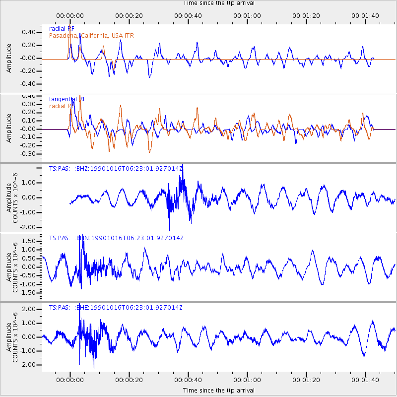
PAS Pasadena, California, USA - Earthquake Result Viewer
*The percent match for this event was below the threshold and hence no stack was calculated.
| Earthquake location: |
Kuril Islands |
| Earthquake latitude/longitude: |
49.0/155.1 |
| Earthquake time(UTC): |
1990/10/16 (289) 06:13:14 GMT |
| Earthquake Depth: |
93 km |
| Earthquake Magnitude: |
6.1 MB |
| Earthquake Catalog/Contributor: |
WHDF/NEIC |
|
| Network: |
TS TERRAscope (Southern California Seismic Network) |
| Station: |
PAS Pasadena, California, USA |
| Lat/Lon: |
34.15 N/118.17 W |
| Elevation: |
295 m |
|
| Distance: |
63.1 deg |
| Az: |
68.156 deg |
| Baz: |
312.539 deg |
| Ray Param: |
$rayparam |
*The percent match for this event was below the threshold and hence was not used in the summary stack. |
|
| Radial Match: |
86.30993 % |
| Radial Bump: |
348 |
| Transverse Match: |
63.80808 % |
| Transverse Bump: |
400 |
| SOD ConfigId: |
4480 |
| Insert Time: |
2010-02-26 14:38:34.111 +0000 |
| GWidth: |
2.5 |
| Max Bumps: |
400 |
| Tol: |
0.001 |
|
Signal To Noise
| Channel | StoN | STA | LTA |
| TS:PAS: :BHN:19901016T06:23:01.927014Z | 2.362602 | 7.8168017E-7 | 3.308556E-7 |
| TS:PAS: :BHE:19901016T06:23:01.927014Z | 2.07242 | 5.88418E-7 | 2.83928E-7 |
| TS:PAS: :BHZ:19901016T06:23:01.927014Z | 1.6346704 | 5.219429E-7 | 3.192955E-7 |
| Arrivals |
| Ps | |
| PpPs | |
| PsPs/PpSs | |


