You are here: Home > Network List > N4 - Central and EAstern US Network Stations List
> Station V58A WIndy Hill, Pittsboro, NC, USA > Earthquake Result Viewer
V58A WIndy Hill, Pittsboro, NC, USA - Earthquake Result Viewer
| Earthquake location: |
Vancouver Island, Canada Region |
| Earthquake latitude/longitude: |
50.6/-129.4 |
| Earthquake time(UTC): |
2019/12/23 (357) 20:56:25 GMT |
| Earthquake Depth: |
0.1 km |
| Earthquake Magnitude: |
2.8 ml |
| Earthquake Catalog/Contributor: |
NEIC PDE/ak |
|
| Network: |
N4 Central and EAstern US Network |
| Station: |
V58A WIndy Hill, Pittsboro, NC, USA |
| Lat/Lon: |
35.79 N/79.11 W |
| Elevation: |
127 m |
|
| Distance: |
38.8 deg |
| Az: |
92.716 deg |
| Baz: |
308.522 deg |
| Ray Param: |
0.07539635 |
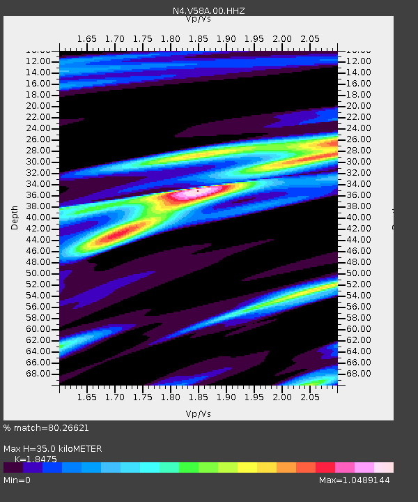
| Estimated Moho Depth: |
35.0 km |
| Estimated Crust Vp/Vs: |
1.85 |
| Assumed Crust Vp: |
6.565 km/s |
| Estimated Crust Vs: |
3.553 km/s |
| Estimated Crust Poisson's Ratio: |
0.29 |
|
| Radial Match: |
80.26621 % |
| Radial Bump: |
399 |
| Transverse Match: |
45.74106 % |
| Transverse Bump: |
400 |
| SOD ConfigId: |
20358551 |
| Insert Time: |
2020-01-06 21:10:06.970 +0000 |
| GWidth: |
2.5 |
| Max Bumps: |
400 |
| Tol: |
0.001 |
|

Signal To Noise
| Channel | StoN | STA | LTA |
| N4:V58A:00:HHZ:20191223T21:03:21.029006Z | 3.1400135 | 1.1761741E-6 | 3.7457616E-7 |
| N4:V58A:00:HH1:20191223T21:03:21.029006Z | 1.7577665 | 5.599101E-7 | 3.1853497E-7 |
| N4:V58A:00:HH2:20191223T21:03:21.029006Z | 1.1673613 | 4.4847462E-7 | 3.841781E-7 |
| Arrivals |
| Ps | 4.9 SECOND |
| PpPs | 14 SECOND |
| PsPs/PpSs | 19 SECOND |


