You are here: Home > Network List > IW - Intermountain West Stations List
> Station PLID Pearl Lake, Idaho, USA > Earthquake Result Viewer
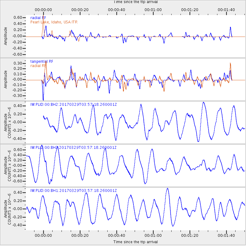
PLID Pearl Lake, Idaho, USA - Earthquake Result Viewer
*The percent match for this event was below the threshold and hence no stack was calculated.
| Earthquake location: |
South Of Panama |
| Earthquake latitude/longitude: |
5.4/-82.6 |
| Earthquake time(UTC): |
2017/03/29 (088) 03:49:01 GMT |
| Earthquake Depth: |
10 km |
| Earthquake Magnitude: |
5.3 Mww |
| Earthquake Catalog/Contributor: |
NEIC PDE/us |
|
| Network: |
IW Intermountain West |
| Station: |
PLID Pearl Lake, Idaho, USA |
| Lat/Lon: |
45.09 N/116.00 W |
| Elevation: |
2164 m |
|
| Distance: |
49.1 deg |
| Az: |
328.939 deg |
| Baz: |
133.517 deg |
| Ray Param: |
$rayparam |
*The percent match for this event was below the threshold and hence was not used in the summary stack. |
|
| Radial Match: |
67.47832 % |
| Radial Bump: |
400 |
| Transverse Match: |
73.13051 % |
| Transverse Bump: |
400 |
| SOD ConfigId: |
2028011 |
| Insert Time: |
2017-04-25 01:47:14.840 +0000 |
| GWidth: |
2.5 |
| Max Bumps: |
400 |
| Tol: |
0.001 |
|
Signal To Noise
| Channel | StoN | STA | LTA |
| IW:PLID:00:BHZ:20170329T03:57:18.260001Z | 1.9147111 | 5.0899223E-7 | 2.658324E-7 |
| IW:PLID:00:BH1:20170329T03:57:18.260001Z | 1.4830525 | 2.3697515E-7 | 1.5978878E-7 |
| IW:PLID:00:BH2:20170329T03:57:18.260001Z | 1.3319614 | 1.9420958E-7 | 1.4580722E-7 |
| Arrivals |
| Ps | |
| PpPs | |
| PsPs/PpSs | |


