You are here: Home > Network List > AE - Arizona Broadband Seismic Network Stations List
> Station TONTO Roosevelt/Tonto Basin > Earthquake Result Viewer
TONTO Roosevelt/Tonto Basin - Earthquake Result Viewer
| Earthquake location: |
Santiago Del Estero Prov., Arg. |
| Earthquake latitude/longitude: |
-27.0/-63.4 |
| Earthquake time(UTC): |
2019/12/24 (358) 16:43:32 GMT |
| Earthquake Depth: |
560 km |
| Earthquake Magnitude: |
6.0 Mww |
| Earthquake Catalog/Contributor: |
NEIC PDE/us |
|
| Network: |
AE Arizona Broadband Seismic Network |
| Station: |
TONTO Roosevelt/Tonto Basin |
| Lat/Lon: |
33.65 N/111.01 W |
| Elevation: |
661 m |
|
| Distance: |
75.4 deg |
| Az: |
320.426 deg |
| Baz: |
137.032 deg |
| Ray Param: |
0.04992735 |
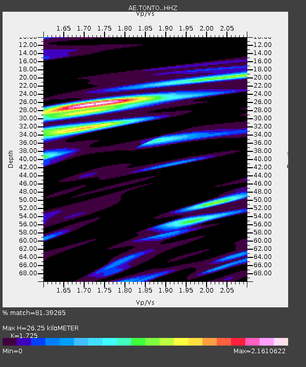
| Estimated Moho Depth: |
26.25 km |
| Estimated Crust Vp/Vs: |
1.73 |
| Assumed Crust Vp: |
6.276 km/s |
| Estimated Crust Vs: |
3.638 km/s |
| Estimated Crust Poisson's Ratio: |
0.25 |
|
| Radial Match: |
81.39265 % |
| Radial Bump: |
400 |
| Transverse Match: |
72.03773 % |
| Transverse Bump: |
400 |
| SOD ConfigId: |
20358551 |
| Insert Time: |
2020-01-07 16:53:37.614 +0000 |
| GWidth: |
2.5 |
| Max Bumps: |
400 |
| Tol: |
0.001 |
|

Signal To Noise
| Channel | StoN | STA | LTA |
| AE:TONTO: :HHZ:20191224T16:53:48.130001Z | 21.424528 | 4.2714223E-6 | 1.9937066E-7 |
| AE:TONTO: :HHN:20191224T16:53:48.130001Z | 7.787418 | 1.6025422E-6 | 2.0578607E-7 |
| AE:TONTO: :HHE:20191224T16:53:48.130001Z | 6.965154 | 1.3882662E-6 | 1.9931593E-7 |
| Arrivals |
| Ps | 3.1 SECOND |
| PpPs | 11 SECOND |
| PsPs/PpSs | 14 SECOND |


