You are here: Home > Network List > MN - MEDNET Project Stations List
> Station CEL Celeste, Italy > Earthquake Result Viewer
CEL Celeste, Italy - Earthquake Result Viewer
| Earthquake location: |
Southern Sumatra, Indonesia |
| Earthquake latitude/longitude: |
-5.0/103.0 |
| Earthquake time(UTC): |
2009/06/20 (171) 09:21:23 GMT |
| Earthquake Depth: |
46 km |
| Earthquake Magnitude: |
5.8 MB, 5.4 MW, 5.4 MW |
| Earthquake Catalog/Contributor: |
WHDF/NEIC |
|
| Network: |
MN MEDNET Project |
| Station: |
CEL Celeste, Italy |
| Lat/Lon: |
38.26 N/15.89 E |
| Elevation: |
702 m |
|
| Distance: |
90.8 deg |
| Az: |
308.156 deg |
| Baz: |
95.654 deg |
| Ray Param: |
0.04163902 |
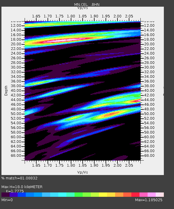
| Estimated Moho Depth: |
18.0 km |
| Estimated Crust Vp/Vs: |
1.78 |
| Assumed Crust Vp: |
5.782 km/s |
| Estimated Crust Vs: |
3.253 km/s |
| Estimated Crust Poisson's Ratio: |
0.27 |
|
| Radial Match: |
81.08832 % |
| Radial Bump: |
400 |
| Transverse Match: |
79.121544 % |
| Transverse Bump: |
400 |
| SOD ConfigId: |
2648 |
| Insert Time: |
2010-03-08 16:53:10.539 +0000 |
| GWidth: |
2.5 |
| Max Bumps: |
400 |
| Tol: |
0.001 |
|

Signal To Noise
| Channel | StoN | STA | LTA |
| MN:CEL: :BHN:20090620T09:33:51.008Z | 10.51304 | 5.002098E-7 | 4.757994E-8 |
| MN:CEL: :BHE:20090620T09:33:51.008Z | 1.9008539 | 8.5303896E-8 | 4.487662E-8 |
| MN:CEL: :BHZ:20090620T09:33:51.008Z | 1.9185135 | 1.00515315E-7 | 5.2392288E-8 |
| Arrivals |
| Ps | 2.5 SECOND |
| PpPs | 8.5 SECOND |
| PsPs/PpSs | 11 SECOND |


