You are here: Home > Network List > MN - MEDNET Project Stations List
> Station CEL Celeste, Italy > Earthquake Result Viewer
CEL Celeste, Italy - Earthquake Result Viewer

| Earthquake location: |
South Of Java, Indonesia |
| Earthquake latitude/longitude: |
-9.3/107.4 |
| Earthquake time(UTC): |
2006/07/17 (198) 08:19:28 GMT |
| Earthquake Depth: |
34 km |
| Earthquake Magnitude: |
6.1 MB, 7.2 MS, 7.7 MW, 7.2 MW |
| Earthquake Catalog/Contributor: |
WHDF/NEIC |
|
| Network: |
MN MEDNET Project |
| Station: |
CEL Celeste, Italy |
| Lat/Lon: |
38.26 N/15.89 E |
| Elevation: |
702 m |
|
| Distance: |
96.8 deg |
| Az: |
307.572 deg |
| Baz: |
96.341 deg |
| Ray Param: |
0.04037765 |
| Estimated Moho Depth: |
15.5 km |
| Estimated Crust Vp/Vs: |
2.03 |
| Assumed Crust Vp: |
5.782 km/s |
| Estimated Crust Vs: |
2.855 km/s |
| Estimated Crust Poisson's Ratio: |
0.34 |
|
| Radial Match: |
88.197495 % |
| Radial Bump: |
400 |
| Transverse Match: |
83.95672 % |
| Transverse Bump: |
400 |
| SOD ConfigId: |
2665 |
| Insert Time: |
2010-03-08 16:53:21.359 +0000 |
| GWidth: |
2.5 |
| Max Bumps: |
400 |
| Tol: |
0.001 |
|
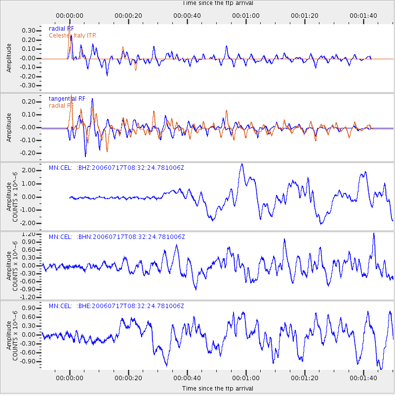
Signal To Noise
| Channel | StoN | STA | LTA |
| MN:CEL: :BHN:20060717T08:32:24.781006Z | 0.6628204 | 4.229396E-8 | 6.3809075E-8 |
| MN:CEL: :BHE:20060717T08:32:24.781006Z | 1.2742596 | 1.1111068E-7 | 8.719626E-8 |
| MN:CEL: :BHZ:20060717T08:32:24.781006Z | 5.4234824 | 2.8874837E-7 | 5.32404E-8 |
| Arrivals |
| Ps | 2.8 SECOND |
| PpPs | 8.0 SECOND |
| PsPs/PpSs | 11 SECOND |


