You are here: Home > Network List > MN - MEDNET Project Stations List
> Station CEL Celeste, Italy > Earthquake Result Viewer
CEL Celeste, Italy - Earthquake Result Viewer
| Earthquake location: |
Taiwan Region |
| Earthquake latitude/longitude: |
22.7/121.5 |
| Earthquake time(UTC): |
2004/05/19 (140) 07:04:11 GMT |
| Earthquake Depth: |
20 km |
| Earthquake Magnitude: |
5.8 MB, 6.1 MS, 6.2 MW, 6.1 MW |
| Earthquake Catalog/Contributor: |
WHDF/NEIC |
|
| Network: |
MN MEDNET Project |
| Station: |
CEL Celeste, Italy |
| Lat/Lon: |
38.26 N/15.89 E |
| Elevation: |
702 m |
|
| Distance: |
87.7 deg |
| Az: |
310.641 deg |
| Baz: |
62.919 deg |
| Ray Param: |
0.043136016 |
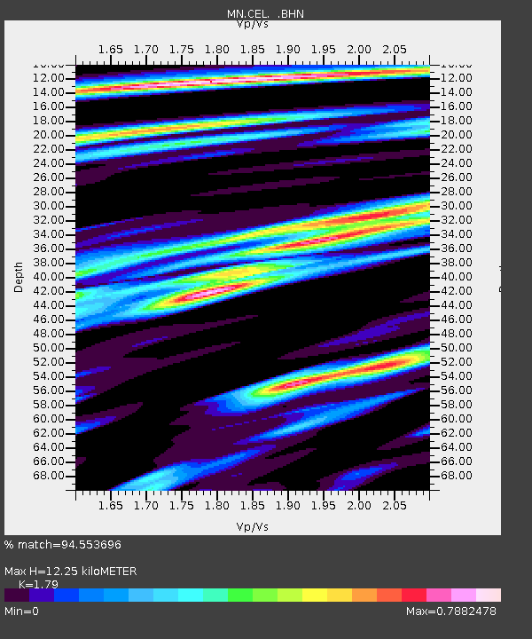
| Estimated Moho Depth: |
12.25 km |
| Estimated Crust Vp/Vs: |
1.79 |
| Assumed Crust Vp: |
5.782 km/s |
| Estimated Crust Vs: |
3.23 km/s |
| Estimated Crust Poisson's Ratio: |
0.27 |
|
| Radial Match: |
94.553696 % |
| Radial Bump: |
400 |
| Transverse Match: |
96.68084 % |
| Transverse Bump: |
399 |
| SOD ConfigId: |
2459 |
| Insert Time: |
2010-03-08 16:53:45.663 +0000 |
| GWidth: |
2.5 |
| Max Bumps: |
400 |
| Tol: |
0.001 |
|

Signal To Noise
| Channel | StoN | STA | LTA |
| MN:CEL: :BHN:20040519T07:16:27.267007Z | 4.062879 | 3.3600793E-7 | 8.270192E-8 |
| MN:CEL: :BHE:20040519T07:16:27.267007Z | 3.2398083 | 2.296728E-7 | 7.089086E-8 |
| MN:CEL: :BHZ:20040519T07:16:27.267007Z | 17.280573 | 1.2284964E-6 | 7.109119E-8 |
| Arrivals |
| Ps | 1.7 SECOND |
| PpPs | 5.8 SECOND |
| PsPs/PpSs | 7.5 SECOND |


