CEL Celeste, Italy - Earthquake Result Viewer
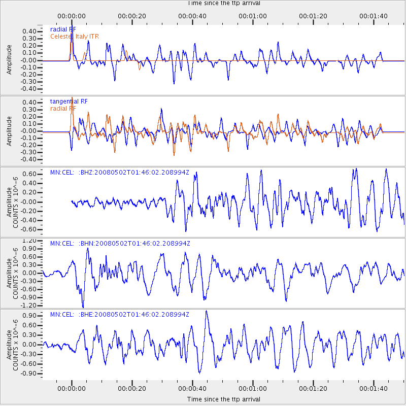
Earthquake location: Andreanof Islands, Aleutian Is.
Earthquake latitude/longitude: 51.9/-177.5
Earthquake time(UTC): 2008/05/02 (123) 01:33:37 GMT
Earthquake Depth: 14 km
Earthquake Magnitude: 6.3 MB, 6.8 MS, 6.6 MW, 6.6 MW
Earthquake Catalog/Contributor: WHDF/NEIC
Network: MN MEDNET Project
Station: CEL Celeste, Italy
Lat/Lon: 38.26 N/15.89 E
Elevation: 702 m
Distance: 89.5 deg
Az: 349.471 deg
Baz: 8.276 deg
Ray Param: 0.041808624
Estimated Moho Depth: 69.75 km
Estimated Crust Vp/Vs: 1.96
Assumed Crust Vp: 5.782 km/s
Estimated Crust Vs: 2.946 km/s
Estimated Crust Poisson's Ratio: 0.32
Radial Match: 87.39652 %
Radial Bump: 400
Transverse Match: 82.44959 %
Transverse Bump: 400
SOD ConfigId: 2504
Insert Time: 2010-03-08 16:53:57.990 +0000
GWidth: 2.5
Max Bumps: 400
Tol: 0.001

Signal To Noise

ChannelStoNSTALTA
MN:CEL: :BHN:20080502T01:46:02.208994Z8.2982995.613972E-76.765209E-8
MN:CEL: :BHE:20080502T01:46:02.208994Z4.05338432.3392838E-75.7711866E-8
MN:CEL: :BHZ:20080502T01:46:02.208994Z4.06792972.0195746E-74.964625E-8
Arrivals
Ps12 SECOND
PpPs35 SECOND
PsPs/PpSs47 SECOND