You are here: Home > Network List > MN - MEDNET Project Stations List
> Station CEL Celeste, Italy > Earthquake Result Viewer
CEL Celeste, Italy - Earthquake Result Viewer

| Earthquake location: |
Xizang |
| Earthquake latitude/longitude: |
30.9/83.5 |
| Earthquake time(UTC): |
2008/08/25 (238) 13:21:58 GMT |
| Earthquake Depth: |
12 km |
| Earthquake Magnitude: |
6.2 MB, 6.5 MS, 6.7 MW, 6.7 MW |
| Earthquake Catalog/Contributor: |
WHDF/NEIC |
|
| Network: |
MN MEDNET Project |
| Station: |
CEL Celeste, Italy |
| Lat/Lon: |
38.26 N/15.89 E |
| Elevation: |
702 m |
|
| Distance: |
55.1 deg |
| Az: |
297.375 deg |
| Baz: |
75.842 deg |
| Ray Param: |
0.065038376 |
| Estimated Moho Depth: |
43.5 km |
| Estimated Crust Vp/Vs: |
1.68 |
| Assumed Crust Vp: |
5.782 km/s |
| Estimated Crust Vs: |
3.437 km/s |
| Estimated Crust Poisson's Ratio: |
0.23 |
|
| Radial Match: |
91.651024 % |
| Radial Bump: |
400 |
| Transverse Match: |
95.971756 % |
| Transverse Bump: |
400 |
| SOD ConfigId: |
2504 |
| Insert Time: |
2010-03-08 16:54:16.951 +0000 |
| GWidth: |
2.5 |
| Max Bumps: |
400 |
| Tol: |
0.001 |
|
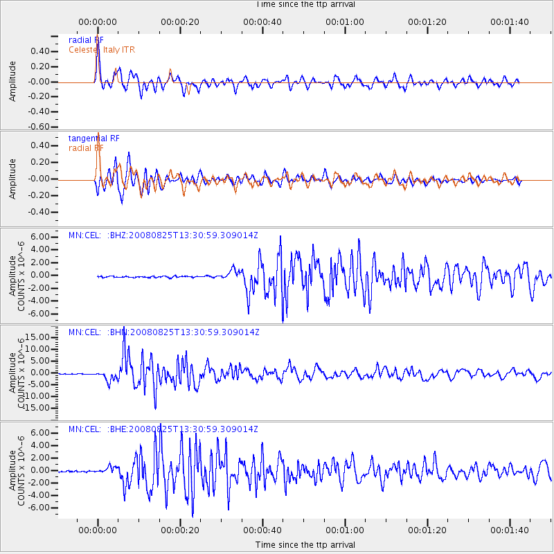
Signal To Noise
| Channel | StoN | STA | LTA |
| MN:CEL: :BHN:20080825T13:30:59.309014Z | 30.244915 | 2.2205638E-6 | 7.341941E-8 |
| MN:CEL: :BHE:20080825T13:30:59.309014Z | 6.1327157 | 5.4208357E-7 | 8.83921E-8 |
| MN:CEL: :BHZ:20080825T13:30:59.309014Z | 8.390636 | 7.835441E-7 | 9.338316E-8 |
| Arrivals |
| Ps | 5.4 SECOND |
| PpPs | 19 SECOND |
| PsPs/PpSs | 25 SECOND |


