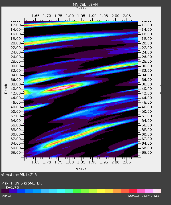
CEL Celeste, Italy - Earthquake Result Viewer
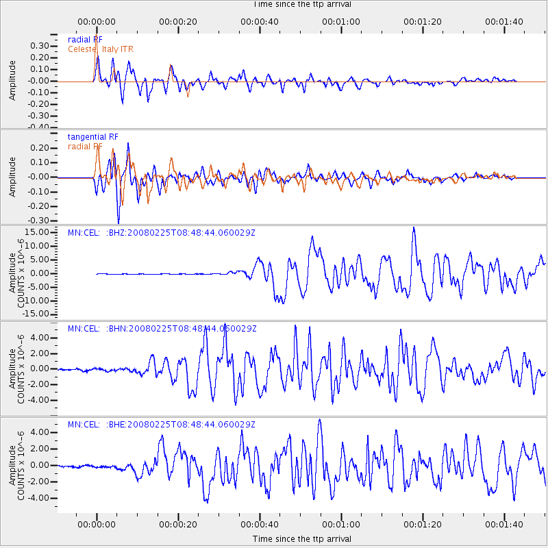
Earthquake location: Southern Sumatra, Indonesia
Earthquake latitude/longitude: -2.5/100.0
Earthquake time(UTC): 2008/02/25 (056) 08:36:33 GMT
Earthquake Depth: 25 km
Earthquake Magnitude: 6.4 MB, 7.3 MS, 7.0 MW, 6.9 MW
Earthquake Catalog/Contributor: WHDF/NEIC
Network: MN MEDNET Project
Station: CEL Celeste, Italy
Lat/Lon: 38.26 N/15.89 E
Elevation: 702 m
Distance: 86.9 deg
Az: 308.354 deg
Baz: 95.603 deg
Ray Param: 0.043708254
Estimated Moho Depth: 39.5 km
Estimated Crust Vp/Vs: 1.76
Assumed Crust Vp: 5.782 km/s
Estimated Crust Vs: 3.285 km/s
Estimated Crust Poisson's Ratio: 0.26
Radial Match: 95.14313 %
Radial Bump: 400
Transverse Match: 96.1617 %
Transverse Bump: 400
SOD ConfigId: 2564
Insert Time: 2010-03-08 16:54:31.240 +0000
GWidth: 2.5
Max Bumps: 400
Tol: 0.001

Signal To Noise

ChannelStoNSTALTA
MN:CEL: :BHN:20080225T08:48:44.060029Z2.8788141.5320593E-75.321842E-8
MN:CEL: :BHE:20080225T08:48:44.060029Z1.13243768.554645E-87.554188E-8
MN:CEL: :BHZ:20080225T08:48:44.060029Z6.55323175.33507E-78.141128E-8
Arrivals
Ps5.3 SECOND
PpPs19 SECOND
PsPs/PpSs24 SECOND