You are here: Home > Network List > MN - MEDNET Project Stations List
> Station CEL Celeste, Italy > Earthquake Result Viewer
CEL Celeste, Italy - Earthquake Result Viewer
| Earthquake location: |
Northern Sumatra, Indonesia |
| Earthquake latitude/longitude: |
1.0/97.4 |
| Earthquake time(UTC): |
2008/01/22 (022) 17:14:57 GMT |
| Earthquake Depth: |
20 km |
| Earthquake Magnitude: |
5.9 MB, 6.2 MW, 6.1 MW |
| Earthquake Catalog/Contributor: |
WHDF/NEIC |
|
| Network: |
MN MEDNET Project |
| Station: |
CEL Celeste, Italy |
| Lat/Lon: |
38.26 N/15.89 E |
| Elevation: |
702 m |
|
| Distance: |
82.7 deg |
| Az: |
308.281 deg |
| Baz: |
94.442 deg |
| Ray Param: |
0.046664808 |
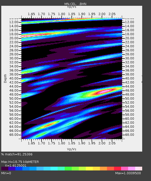
| Estimated Moho Depth: |
18.75 km |
| Estimated Crust Vp/Vs: |
1.61 |
| Assumed Crust Vp: |
5.782 km/s |
| Estimated Crust Vs: |
3.586 km/s |
| Estimated Crust Poisson's Ratio: |
0.19 |
|
| Radial Match: |
91.25386 % |
| Radial Bump: |
400 |
| Transverse Match: |
93.147995 % |
| Transverse Bump: |
400 |
| SOD ConfigId: |
2564 |
| Insert Time: |
2010-03-08 16:54:36.854 +0000 |
| GWidth: |
2.5 |
| Max Bumps: |
400 |
| Tol: |
0.001 |
|

Signal To Noise
| Channel | StoN | STA | LTA |
| MN:CEL: :BHN:20080122T17:26:48.910022Z | 1.2313287 | 1.4501236E-7 | 1.17769005E-7 |
| MN:CEL: :BHE:20080122T17:26:48.910022Z | 2.0472348 | 2.5870403E-7 | 1.2636754E-7 |
| MN:CEL: :BHZ:20080122T17:26:48.910022Z | 7.8610587 | 7.324114E-7 | 9.316957E-8 |
| Arrivals |
| Ps | 2.0 SECOND |
| PpPs | 8.3 SECOND |
| PsPs/PpSs | 10 SECOND |


