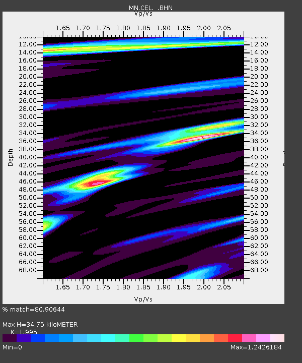
CEL Celeste, Italy - Earthquake Result Viewer

Earthquake location: Andreanof Islands, Aleutian Is.
Earthquake latitude/longitude: 51.4/-179.5
Earthquake time(UTC): 2007/12/19 (353) 09:30:27 GMT
Earthquake Depth: 29 km
Earthquake Magnitude: 6.4 MB, 7.1 MS, 7.1 MW, 7.0 MW
Earthquake Catalog/Contributor: WHDF/NEIC
Network: MN MEDNET Project
Station: CEL Celeste, Italy
Lat/Lon: 38.26 N/15.89 E
Elevation: 702 m
Distance: 89.7 deg
Az: 347.921 deg
Baz: 9.594 deg
Ray Param: 0.04172026
Estimated Moho Depth: 34.75 km
Estimated Crust Vp/Vs: 2.00
Assumed Crust Vp: 5.782 km/s
Estimated Crust Vs: 2.898 km/s
Estimated Crust Poisson's Ratio: 0.33
Radial Match: 80.90644 %
Radial Bump: 400
Transverse Match: 79.63855 %
Transverse Bump: 400
SOD ConfigId: 2564
Insert Time: 2010-03-08 16:55:19.662 +0000
GWidth: 2.5
Max Bumps: 400
Tol: 0.001

Signal To Noise

ChannelStoNSTALTA
MN:CEL: :BHN:20071219T09:42:51.309011Z4.9396178.133902E-71.6466666E-7
MN:CEL: :BHE:20071219T09:42:51.309011Z3.35294585.417931E-71.615872E-7
MN:CEL: :BHZ:20071219T09:42:51.309011Z15.7368572.1775E-61.3836943E-7
Arrivals
Ps6.1 SECOND
PpPs18 SECOND
PsPs/PpSs24 SECOND