You are here: Home > Network List > MN - MEDNET Project Stations List
> Station CEL Celeste, Italy > Earthquake Result Viewer
CEL Celeste, Italy - Earthquake Result Viewer
| Earthquake location: |
Windward Islands |
| Earthquake latitude/longitude: |
15.0/-61.3 |
| Earthquake time(UTC): |
2007/11/29 (333) 19:00:19 GMT |
| Earthquake Depth: |
148 km |
| Earthquake Magnitude: |
6.9 MB, 7.4 MW, 7.4 MW |
| Earthquake Catalog/Contributor: |
WHDF/NEIC |
|
| Network: |
MN MEDNET Project |
| Station: |
CEL Celeste, Italy |
| Lat/Lon: |
38.26 N/15.89 E |
| Elevation: |
702 m |
|
| Distance: |
70.9 deg |
| Az: |
54.322 deg |
| Baz: |
274.227 deg |
| Ray Param: |
0.054303046 |
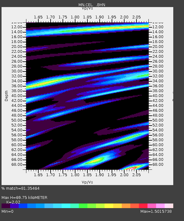
| Estimated Moho Depth: |
69.75 km |
| Estimated Crust Vp/Vs: |
2.02 |
| Assumed Crust Vp: |
5.782 km/s |
| Estimated Crust Vs: |
2.863 km/s |
| Estimated Crust Poisson's Ratio: |
0.34 |
|
| Radial Match: |
81.35464 % |
| Radial Bump: |
400 |
| Transverse Match: |
74.72191 % |
| Transverse Bump: |
400 |
| SOD ConfigId: |
2564 |
| Insert Time: |
2010-03-08 16:55:20.832 +0000 |
| GWidth: |
2.5 |
| Max Bumps: |
400 |
| Tol: |
0.001 |
|

Signal To Noise
| Channel | StoN | STA | LTA |
| MN:CEL: :BHN:20071129T19:10:49.759009Z | 1.1602889 | 3.954475E-7 | 3.4081813E-7 |
| MN:CEL: :BHE:20071129T19:10:49.759009Z | 9.286885 | 2.699692E-6 | 2.906994E-7 |
| MN:CEL: :BHZ:20071129T19:10:49.759009Z | 15.142353 | 6.158719E-6 | 4.0672137E-7 |
| Arrivals |
| Ps | 13 SECOND |
| PpPs | 36 SECOND |
| PsPs/PpSs | 48 SECOND |


