You are here: Home > Network List > MN - MEDNET Project Stations List
> Station CEL Celeste, Italy > Earthquake Result Viewer
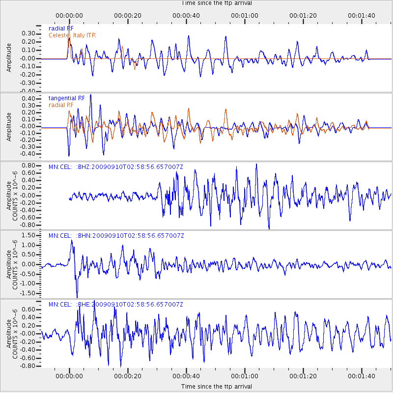
CEL Celeste, Italy - Earthquake Result Viewer

| Earthquake location: |
Kuril Islands |
| Earthquake latitude/longitude: |
48.3/154.2 |
| Earthquake time(UTC): |
2009/09/10 (253) 02:46:50 GMT |
| Earthquake Depth: |
36 km |
| Earthquake Magnitude: |
6.0 MB, 5.5 MS, 6.0 MW, 5.8 MW |
| Earthquake Catalog/Contributor: |
WHDF/NEIC |
|
| Network: |
MN MEDNET Project |
| Station: |
CEL Celeste, Italy |
| Lat/Lon: |
38.26 N/15.89 E |
| Elevation: |
702 m |
|
| Distance: |
86.2 deg |
| Az: |
328.34 deg |
| Baz: |
26.427 deg |
| Ray Param: |
0.044196174 |
| Estimated Moho Depth: |
33.25 km |
| Estimated Crust Vp/Vs: |
2.03 |
| Assumed Crust Vp: |
5.782 km/s |
| Estimated Crust Vs: |
2.855 km/s |
| Estimated Crust Poisson's Ratio: |
0.34 |
|
| Radial Match: |
84.26157 % |
| Radial Bump: |
400 |
| Transverse Match: |
89.47713 % |
| Transverse Bump: |
400 |
| SOD ConfigId: |
2622 |
| Insert Time: |
2010-03-08 16:55:56.613 +0000 |
| GWidth: |
2.5 |
| Max Bumps: |
400 |
| Tol: |
0.001 |
|
Signal To Noise
| Channel | StoN | STA | LTA |
| MN:CEL: :BHN:20090910T02:58:56.657007Z | 12.363017 | 7.3015684E-7 | 5.905976E-8 |
| MN:CEL: :BHE:20090910T02:58:56.657007Z | 4.0396843 | 3.0299427E-7 | 7.5004436E-8 |
| MN:CEL: :BHZ:20090910T02:58:56.657007Z | 3.9033935 | 2.4054145E-7 | 6.162368E-8 |
| Arrivals |
| Ps | 6.0 SECOND |
| PpPs | 17 SECOND |
| PsPs/PpSs | 23 SECOND |


