You are here: Home > Network List > MN - MEDNET Project Stations List
> Station CEL Celeste, Italy > Earthquake Result Viewer
CEL Celeste, Italy - Earthquake Result Viewer
| Earthquake location: |
Southern Sumatra, Indonesia |
| Earthquake latitude/longitude: |
-0.7/99.9 |
| Earthquake time(UTC): |
2009/09/30 (273) 10:16:09 GMT |
| Earthquake Depth: |
81 km |
| Earthquake Magnitude: |
7.1 MB, 7.5 MW, 7.5 MW |
| Earthquake Catalog/Contributor: |
WHDF/NEIC |
|
| Network: |
MN MEDNET Project |
| Station: |
CEL Celeste, Italy |
| Lat/Lon: |
38.26 N/15.89 E |
| Elevation: |
702 m |
|
| Distance: |
85.7 deg |
| Az: |
308.272 deg |
| Baz: |
94.289 deg |
| Ray Param: |
0.04441379 |
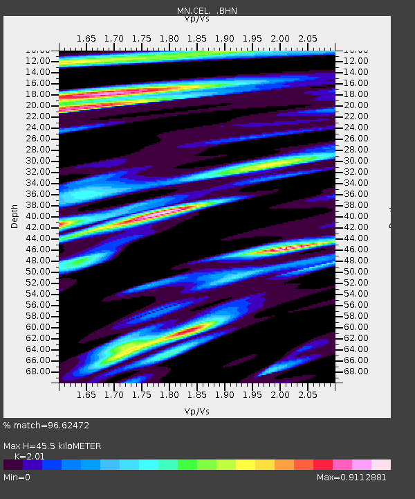
| Estimated Moho Depth: |
45.5 km |
| Estimated Crust Vp/Vs: |
2.01 |
| Assumed Crust Vp: |
5.782 km/s |
| Estimated Crust Vs: |
2.877 km/s |
| Estimated Crust Poisson's Ratio: |
0.34 |
|
| Radial Match: |
96.62472 % |
| Radial Bump: |
400 |
| Transverse Match: |
95.12444 % |
| Transverse Bump: |
400 |
| SOD ConfigId: |
2622 |
| Insert Time: |
2010-03-08 16:56:00.955 +0000 |
| GWidth: |
2.5 |
| Max Bumps: |
400 |
| Tol: |
0.001 |
|
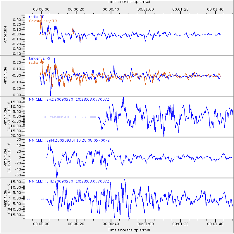
Signal To Noise
| Channel | StoN | STA | LTA |
| MN:CEL: :BHN:20090930T10:28:08.057007Z | 133.36214 | 2.0945534E-5 | 1.5705758E-7 |
| MN:CEL: :BHE:20090930T10:28:08.057007Z | 26.108543 | 1.6069057E-6 | 6.154712E-8 |
| MN:CEL: :BHZ:20090930T10:28:08.057007Z | 37.369225 | 3.9770985E-6 | 1.064271E-7 |
| Arrivals |
| Ps | 8.1 SECOND |
| PpPs | 23 SECOND |
| PsPs/PpSs | 31 SECOND |


