You are here: Home > Network List > MN - MEDNET Project Stations List
> Station CEL Celeste, Italy > Earthquake Result Viewer
CEL Celeste, Italy - Earthquake Result Viewer
| Earthquake location: |
North Of Honduras |
| Earthquake latitude/longitude: |
16.7/-86.2 |
| Earthquake time(UTC): |
2009/05/28 (148) 08:24:45 GMT |
| Earthquake Depth: |
10 km |
| Earthquake Magnitude: |
6.7 MB, 7.2 MS, 7.3 MW, 7.3 MW |
| Earthquake Catalog/Contributor: |
WHDF/NEIC |
|
| Network: |
MN MEDNET Project |
| Station: |
CEL Celeste, Italy |
| Lat/Lon: |
38.26 N/15.89 E |
| Elevation: |
702 m |
|
| Distance: |
89.0 deg |
| Az: |
50.334 deg |
| Baz: |
290.444 deg |
| Ray Param: |
0.042185966 |
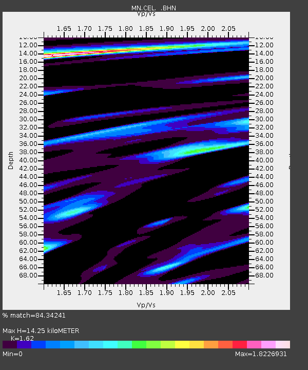
| Estimated Moho Depth: |
14.25 km |
| Estimated Crust Vp/Vs: |
1.62 |
| Assumed Crust Vp: |
5.782 km/s |
| Estimated Crust Vs: |
3.569 km/s |
| Estimated Crust Poisson's Ratio: |
0.19 |
|
| Radial Match: |
84.34241 % |
| Radial Bump: |
400 |
| Transverse Match: |
71.962875 % |
| Transverse Bump: |
400 |
| SOD ConfigId: |
2648 |
| Insert Time: |
2010-03-08 16:56:05.030 +0000 |
| GWidth: |
2.5 |
| Max Bumps: |
400 |
| Tol: |
0.001 |
|
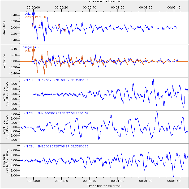
Signal To Noise
| Channel | StoN | STA | LTA |
| MN:CEL: :BHN:20090528T08:37:08.358015Z | 4.4084945 | 4.5780376E-7 | 1.0384583E-7 |
| MN:CEL: :BHE:20090528T08:37:08.358015Z | 1.1631304 | 1.3298704E-7 | 1.1433546E-7 |
| MN:CEL: :BHZ:20090528T08:37:08.358015Z | 1.5915143 | 2.196817E-7 | 1.3803313E-7 |
| Arrivals |
| Ps | 1.6 SECOND |
| PpPs | 6.3 SECOND |
| PsPs/PpSs | 7.9 SECOND |


