You are here: Home > Network List > UW - Pacific Northwest Regional Seismic Network Stations List
> Station UMAT Pilot Rock, OR, USA > Earthquake Result Viewer
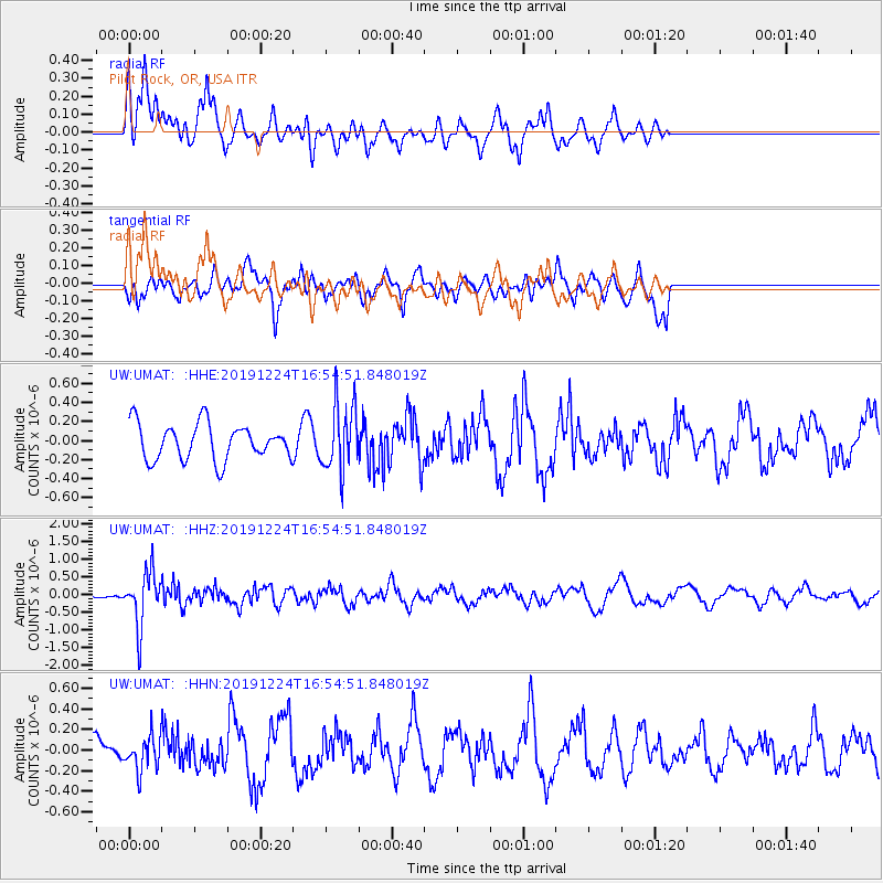
UMAT Pilot Rock, OR, USA - Earthquake Result Viewer
*The percent match for this event was below the threshold and hence no stack was calculated.
| Earthquake location: |
Santiago Del Estero Prov., Arg. |
| Earthquake latitude/longitude: |
-27.0/-63.4 |
| Earthquake time(UTC): |
2019/12/24 (358) 16:43:32 GMT |
| Earthquake Depth: |
560 km |
| Earthquake Magnitude: |
6.0 Mww |
| Earthquake Catalog/Contributor: |
NEIC PDE/us |
|
| Network: |
UW Pacific Northwest Regional Seismic Network |
| Station: |
UMAT Pilot Rock, OR, USA |
| Lat/Lon: |
45.29 N/118.96 W |
| Elevation: |
1318 m |
|
| Distance: |
87.9 deg |
| Az: |
324.354 deg |
| Baz: |
132.541 deg |
| Ray Param: |
$rayparam |
*The percent match for this event was below the threshold and hence was not used in the summary stack. |
|
| Radial Match: |
69.60251 % |
| Radial Bump: |
400 |
| Transverse Match: |
58.586906 % |
| Transverse Bump: |
400 |
| SOD ConfigId: |
20358551 |
| Insert Time: |
2020-01-07 17:04:31.870 +0000 |
| GWidth: |
2.5 |
| Max Bumps: |
400 |
| Tol: |
0.001 |
|
Signal To Noise
| Channel | StoN | STA | LTA |
| UW:UMAT: :HHZ:20191224T16:54:51.848019Z | 5.2247987 | 7.522816E-7 | 1.4398289E-7 |
| UW:UMAT: :HHN:20191224T16:54:51.848019Z | 0.77937984 | 1.5731784E-7 | 2.0185001E-7 |
| UW:UMAT: :HHE:20191224T16:54:51.848019Z | 1.8684926 | 3.5151376E-7 | 1.8812692E-7 |
| Arrivals |
| Ps | |
| PpPs | |
| PsPs/PpSs | |


