You are here: Home > Network List > US - United States National Seismic Network Stations List
> Station HAWA Hanford, Washington, USA > Earthquake Result Viewer
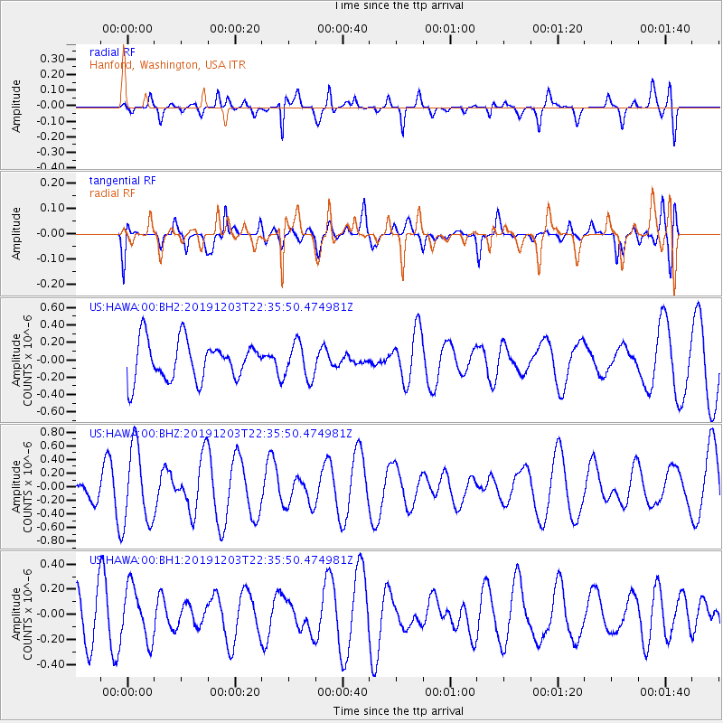
HAWA Hanford, Washington, USA - Earthquake Result Viewer
*The percent match for this event was below the threshold and hence no stack was calculated.
| Earthquake location: |
New Ireland Region, P.N.G. |
| Earthquake latitude/longitude: |
-3.2/150.8 |
| Earthquake time(UTC): |
2019/12/03 (337) 22:23:13 GMT |
| Earthquake Depth: |
10 km |
| Earthquake Magnitude: |
5.6 Mww |
| Earthquake Catalog/Contributor: |
NEIC PDE/us |
|
| Network: |
US United States National Seismic Network |
| Station: |
HAWA Hanford, Washington, USA |
| Lat/Lon: |
46.39 N/119.53 W |
| Elevation: |
364 m |
|
| Distance: |
92.1 deg |
| Az: |
43.836 deg |
| Baz: |
267.586 deg |
| Ray Param: |
$rayparam |
*The percent match for this event was below the threshold and hence was not used in the summary stack. |
|
| Radial Match: |
49.62495 % |
| Radial Bump: |
400 |
| Transverse Match: |
40.51852 % |
| Transverse Bump: |
400 |
| SOD ConfigId: |
20465011 |
| Insert Time: |
2020-01-07 18:03:55.843 +0000 |
| GWidth: |
2.5 |
| Max Bumps: |
400 |
| Tol: |
0.001 |
|
Signal To Noise
| Channel | StoN | STA | LTA |
| US:HAWA:00:BHZ:20191203T22:35:50.474981Z | 1.498781 | 5.598785E-7 | 3.7355596E-7 |
| US:HAWA:00:BH1:20191203T22:35:50.474981Z | 1.1356908 | 2.1110316E-7 | 1.8588085E-7 |
| US:HAWA:00:BH2:20191203T22:35:50.474981Z | 0.90318424 | 1.9509807E-7 | 2.1601137E-7 |
| Arrivals |
| Ps | |
| PpPs | |
| PsPs/PpSs | |


