You are here: Home > Network List > MN - MEDNET Project Stations List
> Station CII Isernia, Italy > Earthquake Result Viewer
CII Isernia, Italy - Earthquake Result Viewer

| Earthquake location: |
Southern Iran |
| Earthquake latitude/longitude: |
28.3/57.2 |
| Earthquake time(UTC): |
1999/03/04 (063) 05:38:26 GMT |
| Earthquake Depth: |
33 km |
| Earthquake Magnitude: |
6.2 MB, 6.5 MS, 6.6 MW, 6.4 MW |
| Earthquake Catalog/Contributor: |
WHDF/NEIC |
|
| Network: |
MN MEDNET Project |
| Station: |
CII Isernia, Italy |
| Lat/Lon: |
41.72 N/14.31 E |
| Elevation: |
910 m |
|
| Distance: |
37.2 deg |
| Az: |
302.567 deg |
| Baz: |
97.095 deg |
| Ray Param: |
0.076207966 |
| Estimated Moho Depth: |
17.75 km |
| Estimated Crust Vp/Vs: |
1.60 |
| Assumed Crust Vp: |
6.1 km/s |
| Estimated Crust Vs: |
3.812 km/s |
| Estimated Crust Poisson's Ratio: |
0.18 |
|
| Radial Match: |
81.911194 % |
| Radial Bump: |
400 |
| Transverse Match: |
62.99208 % |
| Transverse Bump: |
400 |
| SOD ConfigId: |
4480 |
| Insert Time: |
2010-03-08 16:57:15.883 +0000 |
| GWidth: |
2.5 |
| Max Bumps: |
400 |
| Tol: |
0.001 |
|
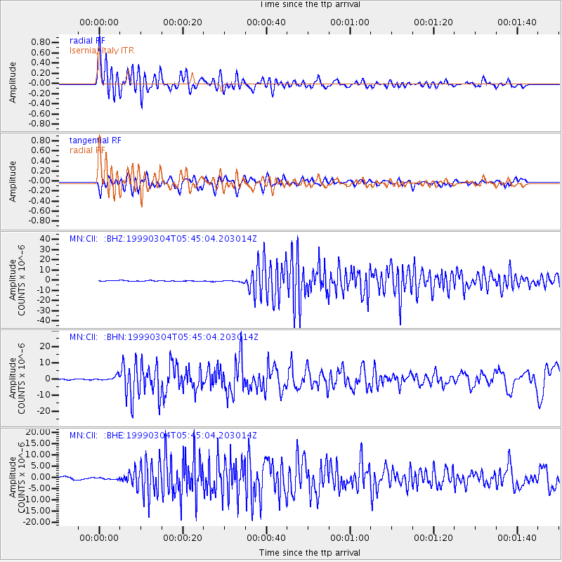
Signal To Noise
| Channel | StoN | STA | LTA |
| MN:CII: :BHN:19990304T05:45:04.203014Z | 3.8550565 | 1.53587E-6 | 3.98404E-7 |
| MN:CII: :BHE:19990304T05:45:04.203014Z | 0.6669525 | 4.4559775E-7 | 6.681102E-7 |
| MN:CII: :BHZ:19990304T05:45:04.203014Z | 2.3832097 | 8.413581E-7 | 3.5303572E-7 |
| Arrivals |
| Ps | 1.9 SECOND |
| PpPs | 7.0 SECOND |
| PsPs/PpSs | 8.9 SECOND |


