You are here: Home > Network List > MN - MEDNET Project Stations List
> Station CII Isernia, Italy > Earthquake Result Viewer
CII Isernia, Italy - Earthquake Result Viewer

| Earthquake location: |
Southern India |
| Earthquake latitude/longitude: |
23.4/70.2 |
| Earthquake time(UTC): |
2001/01/26 (026) 03:16:40 GMT |
| Earthquake Depth: |
16 km |
| Earthquake Magnitude: |
6.9 MB, 8.0 MS, 7.7 MW, 7.7 ME |
| Earthquake Catalog/Contributor: |
WHDF/NEIC |
|
| Network: |
MN MEDNET Project |
| Station: |
CII Isernia, Italy |
| Lat/Lon: |
41.72 N/14.31 E |
| Elevation: |
910 m |
|
| Distance: |
49.7 deg |
| Az: |
305.562 deg |
| Baz: |
93.413 deg |
| Ray Param: |
0.0685428 |
| Estimated Moho Depth: |
33.5 km |
| Estimated Crust Vp/Vs: |
1.74 |
| Assumed Crust Vp: |
6.1 km/s |
| Estimated Crust Vs: |
3.506 km/s |
| Estimated Crust Poisson's Ratio: |
0.25 |
|
| Radial Match: |
88.188 % |
| Radial Bump: |
400 |
| Transverse Match: |
89.2957 % |
| Transverse Bump: |
400 |
| SOD ConfigId: |
3744 |
| Insert Time: |
2010-03-08 16:57:18.695 +0000 |
| GWidth: |
2.5 |
| Max Bumps: |
400 |
| Tol: |
0.001 |
|
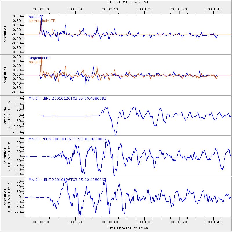
Signal To Noise
| Channel | StoN | STA | LTA |
| MN:CII: :BHN:20010126T03:25:00.428009Z | 0.8566079 | 5.639646E-7 | 6.583696E-7 |
| MN:CII: :BHE:20010126T03:25:00.428009Z | 1.2352203 | 1.0514569E-6 | 8.512303E-7 |
| MN:CII: :BHZ:20010126T03:25:00.428009Z | 7.83523 | 4.04137E-6 | 5.1579474E-7 |
| Arrivals |
| Ps | 4.3 SECOND |
| PpPs | 14 SECOND |
| PsPs/PpSs | 19 SECOND |


