You are here: Home > Network List > US - United States National Seismic Network Stations List
> Station DGMT Dagmar, Montana, USA > Earthquake Result Viewer
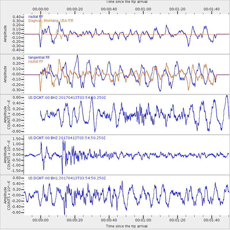
DGMT Dagmar, Montana, USA - Earthquake Result Viewer
*The percent match for this event was below the threshold and hence no stack was calculated.
| Earthquake location: |
Near Coast Of Central Chile |
| Earthquake latitude/longitude: |
-31.0/-71.4 |
| Earthquake time(UTC): |
2017/04/13 (103) 03:42:53 GMT |
| Earthquake Depth: |
43 km |
| Earthquake Magnitude: |
5.4 Mwr |
| Earthquake Catalog/Contributor: |
NEIC PDE/us |
|
| Network: |
US United States National Seismic Network |
| Station: |
DGMT Dagmar, Montana, USA |
| Lat/Lon: |
48.47 N/104.20 W |
| Elevation: |
0.0 m |
|
| Distance: |
84.4 deg |
| Az: |
338.765 deg |
| Baz: |
152.149 deg |
| Ray Param: |
$rayparam |
*The percent match for this event was below the threshold and hence was not used in the summary stack. |
|
| Radial Match: |
48.90772 % |
| Radial Bump: |
400 |
| Transverse Match: |
45.519993 % |
| Transverse Bump: |
400 |
| SOD ConfigId: |
2028011 |
| Insert Time: |
2017-04-27 03:52:16.656 +0000 |
| GWidth: |
2.5 |
| Max Bumps: |
400 |
| Tol: |
0.001 |
|
Signal To Noise
| Channel | StoN | STA | LTA |
| US:DGMT:00:BHZ:20170413T03:54:50.250Z | 3.0547616 | 5.4714553E-7 | 1.7911236E-7 |
| US:DGMT:00:BH1:20170413T03:54:50.250Z | 0.987228 | 1.9862144E-7 | 2.0119106E-7 |
| US:DGMT:00:BH2:20170413T03:54:50.250Z | 1.7047946 | 3.6174632E-7 | 2.1219348E-7 |
| Arrivals |
| Ps | |
| PpPs | |
| PsPs/PpSs | |


