You are here: Home > Network List > MN - MEDNET Project Stations List
> Station CII Isernia, Italy > Earthquake Result Viewer
CII Isernia, Italy - Earthquake Result Viewer
| Earthquake location: |
Xizang |
| Earthquake latitude/longitude: |
30.1/88.2 |
| Earthquake time(UTC): |
1998/07/20 (201) 01:05:58 GMT |
| Earthquake Depth: |
33 km |
| Earthquake Magnitude: |
5.7 UNKNOWN, 5.4 MS, 5.4 MB |
| Earthquake Catalog/Contributor: |
WHDF/NEIC |
|
| Network: |
MN MEDNET Project |
| Station: |
CII Isernia, Italy |
| Lat/Lon: |
41.72 N/14.31 E |
| Elevation: |
910 m |
|
| Distance: |
59.2 deg |
| Az: |
303.196 deg |
| Baz: |
75.558 deg |
| Ray Param: |
0.062258903 |
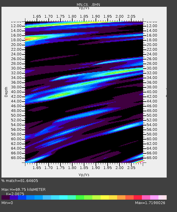
| Estimated Moho Depth: |
69.75 km |
| Estimated Crust Vp/Vs: |
2.09 |
| Assumed Crust Vp: |
6.1 km/s |
| Estimated Crust Vs: |
2.922 km/s |
| Estimated Crust Poisson's Ratio: |
0.35 |
|
| Radial Match: |
81.64605 % |
| Radial Bump: |
400 |
| Transverse Match: |
78.67944 % |
| Transverse Bump: |
400 |
| SOD ConfigId: |
4480 |
| Insert Time: |
2010-03-08 16:57:36.741 +0000 |
| GWidth: |
2.5 |
| Max Bumps: |
400 |
| Tol: |
0.001 |
|

Signal To Noise
| Channel | StoN | STA | LTA |
| MN:CII: :BHN:19980720T01:15:25.703015Z | 2.7682722 | 3.4896422E-7 | 1.2605848E-7 |
| MN:CII: :BHE:19980720T01:15:25.703015Z | 0.804982 | 7.666951E-8 | 9.5243756E-8 |
| MN:CII: :BHZ:19980720T01:15:25.703015Z | 1.4372948 | 1.4255504E-7 | 9.918288E-8 |
| Arrivals |
| Ps | 13 SECOND |
| PpPs | 34 SECOND |
| PsPs/PpSs | 47 SECOND |


