You are here: Home > Network List > MN - MEDNET Project Stations List
> Station CII Isernia, Italy > Earthquake Result Viewer
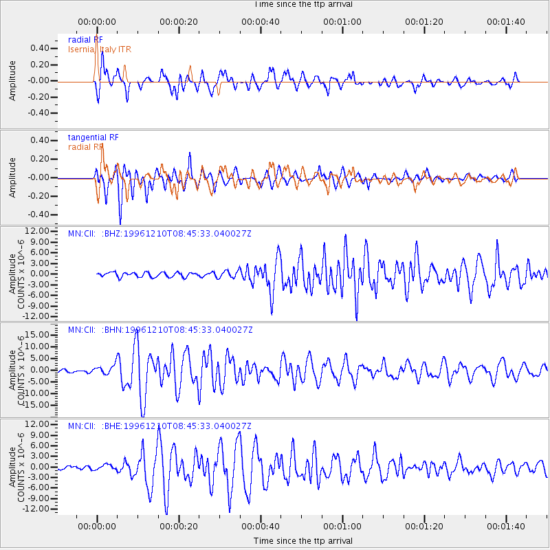
CII Isernia, Italy - Earthquake Result Viewer
*The percent match for this event was below the threshold and hence no stack was calculated.
| Earthquake location: |
Central Mid-Atlantic Ridge |
| Earthquake latitude/longitude: |
0.9/-30.0 |
| Earthquake time(UTC): |
1996/12/10 (345) 08:36:18 GMT |
| Earthquake Depth: |
10 km |
| Earthquake Magnitude: |
6.0 MB, 6.2 MS, 6.6 UNKNOWN, 6.6 MW |
| Earthquake Catalog/Contributor: |
WHDF/NEIC |
|
| Network: |
MN MEDNET Project |
| Station: |
CII Isernia, Italy |
| Lat/Lon: |
41.72 N/14.31 E |
| Elevation: |
910 m |
|
| Distance: |
57.0 deg |
| Az: |
38.624 deg |
| Baz: |
236.486 deg |
| Ray Param: |
$rayparam |
*The percent match for this event was below the threshold and hence was not used in the summary stack. |
|
| Radial Match: |
70.950645 % |
| Radial Bump: |
400 |
| Transverse Match: |
79.32021 % |
| Transverse Bump: |
400 |
| SOD ConfigId: |
4480 |
| Insert Time: |
2010-03-08 16:57:39.608 +0000 |
| GWidth: |
2.5 |
| Max Bumps: |
400 |
| Tol: |
0.001 |
|
Signal To Noise
| Channel | StoN | STA | LTA |
| MN:CII: :BHN:19961210T08:45:33.040027Z | 4.610654 | 2.1025596E-6 | 4.56022E-7 |
| MN:CII: :BHE:19961210T08:45:33.040027Z | 1.3944638 | 8.057552E-7 | 5.7782444E-7 |
| MN:CII: :BHZ:19961210T08:45:33.040027Z | 1.5829351 | 1.012026E-6 | 6.393351E-7 |
| Arrivals |
| Ps | |
| PpPs | |
| PsPs/PpSs | |


