You are here: Home > Network List > MN - MEDNET Project Stations List
> Station CII Isernia, Italy > Earthquake Result Viewer
CII Isernia, Italy - Earthquake Result Viewer
*The percent match for this event was below the threshold and hence no stack was calculated.
| Earthquake location: |
Kuril Islands |
| Earthquake latitude/longitude: |
43.5/147.2 |
| Earthquake time(UTC): |
1994/11/09 (313) 18:21:03 GMT |
| Earthquake Depth: |
61 km |
| Earthquake Magnitude: |
6.1 MB, 5.8 UNKNOWN, 5.8 MW |
| Earthquake Catalog/Contributor: |
WHDF/NEIC |
|
| Network: |
MN MEDNET Project |
| Station: |
CII Isernia, Italy |
| Lat/Lon: |
41.72 N/14.31 E |
| Elevation: |
910 m |
|
| Distance: |
85.2 deg |
| Az: |
326.6 deg |
| Baz: |
32.337 deg |
| Ray Param: |
$rayparam |
*The percent match for this event was below the threshold and hence was not used in the summary stack. |
|
| Radial Match: |
65.526855 % |
| Radial Bump: |
400 |
| Transverse Match: |
66.52781 % |
| Transverse Bump: |
400 |
| SOD ConfigId: |
4480 |
| Insert Time: |
2010-03-08 16:57:45.466 +0000 |
| GWidth: |
2.5 |
| Max Bumps: |
400 |
| Tol: |
0.001 |
|
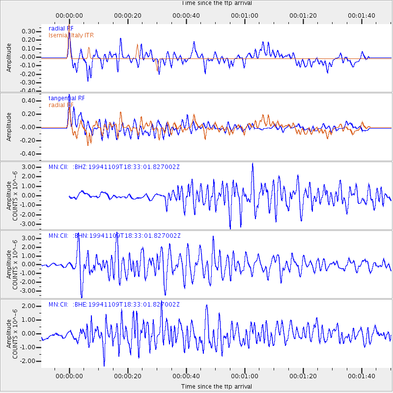
Signal To Noise
| Channel | StoN | STA | LTA |
| MN:CII: :BHN:19941109T18:33:01.827002Z | 7.626671 | 1.7279585E-6 | 2.2656786E-7 |
| MN:CII: :BHE:19941109T18:33:01.827002Z | 0.79664254 | 3.1895345E-7 | 4.003721E-7 |
| MN:CII: :BHZ:19941109T18:33:01.827002Z | 2.1459334 | 4.783802E-7 | 2.2292407E-7 |
| Arrivals |
| Ps | |
| PpPs | |
| PsPs/PpSs | |


