You are here: Home > Network List > US - United States National Seismic Network Stations List
> Station HDIL Hopedale, Illinois, USA > Earthquake Result Viewer
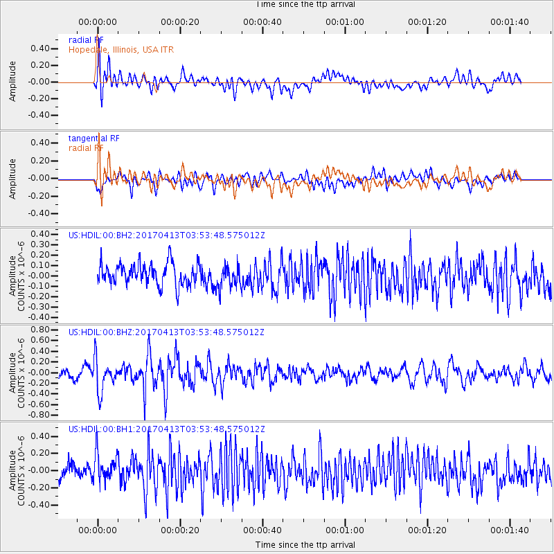
HDIL Hopedale, Illinois, USA - Earthquake Result Viewer
*The percent match for this event was below the threshold and hence no stack was calculated.
| Earthquake location: |
Near Coast Of Central Chile |
| Earthquake latitude/longitude: |
-31.0/-71.4 |
| Earthquake time(UTC): |
2017/04/13 (103) 03:42:53 GMT |
| Earthquake Depth: |
43 km |
| Earthquake Magnitude: |
5.4 Mwr |
| Earthquake Catalog/Contributor: |
NEIC PDE/us |
|
| Network: |
US United States National Seismic Network |
| Station: |
HDIL Hopedale, Illinois, USA |
| Lat/Lon: |
40.56 N/89.29 W |
| Elevation: |
219 m |
|
| Distance: |
73.1 deg |
| Az: |
345.838 deg |
| Baz: |
164.001 deg |
| Ray Param: |
$rayparam |
*The percent match for this event was below the threshold and hence was not used in the summary stack. |
|
| Radial Match: |
55.79555 % |
| Radial Bump: |
400 |
| Transverse Match: |
51.521584 % |
| Transverse Bump: |
400 |
| SOD ConfigId: |
2028011 |
| Insert Time: |
2017-04-27 03:52:44.805 +0000 |
| GWidth: |
2.5 |
| Max Bumps: |
400 |
| Tol: |
0.001 |
|
Signal To Noise
| Channel | StoN | STA | LTA |
| US:HDIL:00:BHZ:20170413T03:53:48.575012Z | 3.164095 | 3.1272384E-7 | 9.883516E-8 |
| US:HDIL:00:BH1:20170413T03:53:48.575012Z | 1.6781555 | 1.7816608E-7 | 1.06167796E-7 |
| US:HDIL:00:BH2:20170413T03:53:48.575012Z | 1.0271938 | 1.0615679E-7 | 1.033464E-7 |
| Arrivals |
| Ps | |
| PpPs | |
| PsPs/PpSs | |


