You are here: Home > Network List > O2 - Oklahoma Consolidated Temporary Seismic Networks Stations List
> Station PERK Perkins, Oklahoma, USA > Earthquake Result Viewer
PERK Perkins, Oklahoma, USA - Earthquake Result Viewer
| Earthquake location: |
Colombia |
| Earthquake latitude/longitude: |
3.5/-74.0 |
| Earthquake time(UTC): |
2019/12/24 (358) 19:03:52 GMT |
| Earthquake Depth: |
11 km |
| Earthquake Magnitude: |
6.0 Mww |
| Earthquake Catalog/Contributor: |
NEIC PDE/us |
|
| Network: |
O2 Oklahoma Consolidated Temporary Seismic Networks |
| Station: |
PERK Perkins, Oklahoma, USA |
| Lat/Lon: |
35.93 N/97.13 W |
| Elevation: |
288 m |
|
| Distance: |
38.7 deg |
| Az: |
329.385 deg |
| Baz: |
141.223 deg |
| Ray Param: |
0.07545278 |
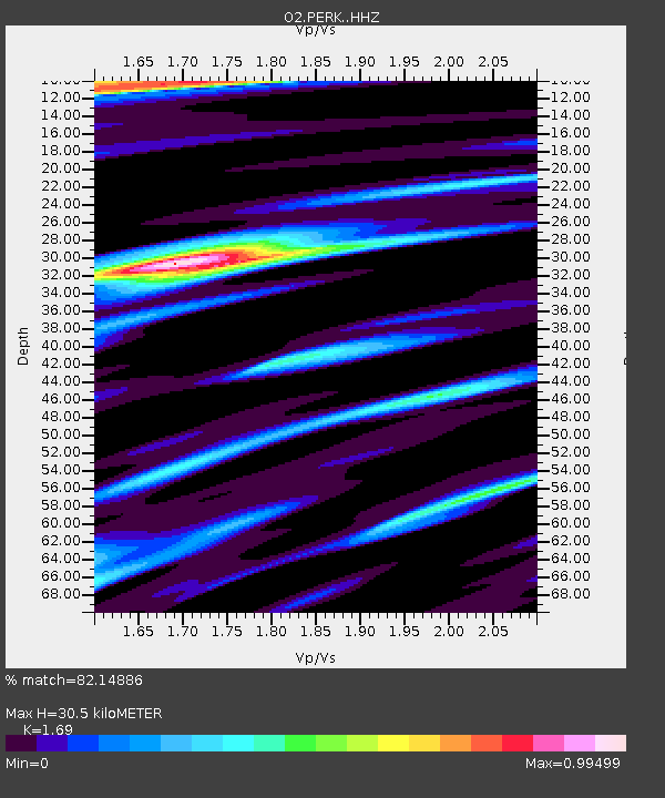
| Estimated Moho Depth: |
30.5 km |
| Estimated Crust Vp/Vs: |
1.69 |
| Assumed Crust Vp: |
6.426 km/s |
| Estimated Crust Vs: |
3.802 km/s |
| Estimated Crust Poisson's Ratio: |
0.23 |
|
| Radial Match: |
82.14886 % |
| Radial Bump: |
400 |
| Transverse Match: |
59.531593 % |
| Transverse Bump: |
400 |
| SOD ConfigId: |
20465011 |
| Insert Time: |
2020-01-07 22:21:59.571 +0000 |
| GWidth: |
2.5 |
| Max Bumps: |
400 |
| Tol: |
0.001 |
|

Signal To Noise
| Channel | StoN | STA | LTA |
| O2:PERK: :HHZ:20191224T19:10:45.139992Z | 8.119238 | 1.3746329E-6 | 1.6930566E-7 |
| O2:PERK: :HHN:20191224T19:10:45.139992Z | 2.1628113 | 5.8366436E-7 | 2.6986376E-7 |
| O2:PERK: :HHE:20191224T19:10:45.139992Z | 1.7264091 | 5.7467514E-7 | 3.328731E-7 |
| Arrivals |
| Ps | 3.5 SECOND |
| PpPs | 12 SECOND |
| PsPs/PpSs | 15 SECOND |


