You are here: Home > Network List > US - United States National Seismic Network Stations List
> Station LKWY Lake (Yellowstone--Lake), Wyoming, USA > Earthquake Result Viewer
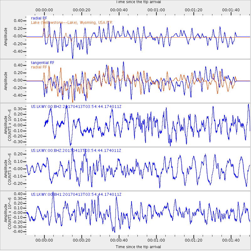
LKWY Lake (Yellowstone--Lake), Wyoming, USA - Earthquake Result Viewer
*The percent match for this event was below the threshold and hence no stack was calculated.
| Earthquake location: |
Near Coast Of Central Chile |
| Earthquake latitude/longitude: |
-31.0/-71.4 |
| Earthquake time(UTC): |
2017/04/13 (103) 03:42:53 GMT |
| Earthquake Depth: |
43 km |
| Earthquake Magnitude: |
5.4 Mwr |
| Earthquake Catalog/Contributor: |
NEIC PDE/us |
|
| Network: |
US United States National Seismic Network |
| Station: |
LKWY Lake (Yellowstone--Lake), Wyoming, USA |
| Lat/Lon: |
44.57 N/110.40 W |
| Elevation: |
2424 m |
|
| Distance: |
83.2 deg |
| Az: |
333.062 deg |
| Baz: |
147.042 deg |
| Ray Param: |
$rayparam |
*The percent match for this event was below the threshold and hence was not used in the summary stack. |
|
| Radial Match: |
49.734276 % |
| Radial Bump: |
400 |
| Transverse Match: |
48.226795 % |
| Transverse Bump: |
400 |
| SOD ConfigId: |
2028011 |
| Insert Time: |
2017-04-27 03:53:06.487 +0000 |
| GWidth: |
2.5 |
| Max Bumps: |
400 |
| Tol: |
0.001 |
|
Signal To Noise
| Channel | StoN | STA | LTA |
| US:LKWY:00:BHZ:20170413T03:54:44.174011Z | 1.733903 | 1.07027525E-7 | 6.172636E-8 |
| US:LKWY:00:BH1:20170413T03:54:44.174011Z | 1.6733469 | 1.8390858E-7 | 1.0990464E-7 |
| US:LKWY:00:BH2:20170413T03:54:44.174011Z | 0.7183882 | 1.0698808E-7 | 1.4892795E-7 |
| Arrivals |
| Ps | |
| PpPs | |
| PsPs/PpSs | |


