You are here: Home > Network List > O2 - Oklahoma Consolidated Temporary Seismic Networks Stations List
> Station PW01 Pawnee, Oklahoma > Earthquake Result Viewer
PW01 Pawnee, Oklahoma - Earthquake Result Viewer
| Earthquake location: |
Colombia |
| Earthquake latitude/longitude: |
3.5/-74.0 |
| Earthquake time(UTC): |
2019/12/24 (358) 19:03:52 GMT |
| Earthquake Depth: |
11 km |
| Earthquake Magnitude: |
6.0 Mww |
| Earthquake Catalog/Contributor: |
NEIC PDE/us |
|
| Network: |
O2 Oklahoma Consolidated Temporary Seismic Networks |
| Station: |
PW01 Pawnee, Oklahoma |
| Lat/Lon: |
36.40 N/96.93 W |
| Elevation: |
322 m |
|
| Distance: |
38.9 deg |
| Az: |
330.059 deg |
| Baz: |
141.865 deg |
| Ray Param: |
0.07529339 |
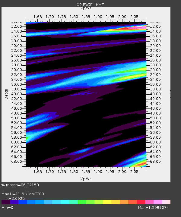
| Estimated Moho Depth: |
11.5 km |
| Estimated Crust Vp/Vs: |
2.09 |
| Assumed Crust Vp: |
6.483 km/s |
| Estimated Crust Vs: |
3.098 km/s |
| Estimated Crust Poisson's Ratio: |
0.35 |
|
| Radial Match: |
86.32158 % |
| Radial Bump: |
332 |
| Transverse Match: |
79.029625 % |
| Transverse Bump: |
400 |
| SOD ConfigId: |
20465011 |
| Insert Time: |
2020-01-07 22:22:02.507 +0000 |
| GWidth: |
2.5 |
| Max Bumps: |
400 |
| Tol: |
0.001 |
|

Signal To Noise
| Channel | StoN | STA | LTA |
| O2:PW01: :HHZ:20191224T19:10:47.405007Z | 4.590273 | 1.2941447E-6 | 2.81932E-7 |
| O2:PW01: :HHN:20191224T19:10:47.405007Z | 3.155095 | 8.29275E-7 | 2.6283678E-7 |
| O2:PW01: :HHE:20191224T19:10:47.405007Z | 1.0360138 | 3.0330955E-7 | 2.9276592E-7 |
| Arrivals |
| Ps | 2.1 SECOND |
| PpPs | 5.2 SECOND |
| PsPs/PpSs | 7.2 SECOND |


