You are here: Home > Network List > O2 - Oklahoma Consolidated Temporary Seismic Networks Stations List
> Station PW02 Pawnee, Oklahoma, USA > Earthquake Result Viewer
PW02 Pawnee, Oklahoma, USA - Earthquake Result Viewer
| Earthquake location: |
Colombia |
| Earthquake latitude/longitude: |
3.5/-74.0 |
| Earthquake time(UTC): |
2019/12/24 (358) 19:03:52 GMT |
| Earthquake Depth: |
11 km |
| Earthquake Magnitude: |
6.0 Mww |
| Earthquake Catalog/Contributor: |
NEIC PDE/us |
|
| Network: |
O2 Oklahoma Consolidated Temporary Seismic Networks |
| Station: |
PW02 Pawnee, Oklahoma, USA |
| Lat/Lon: |
36.42 N/96.86 W |
| Elevation: |
314 m |
|
| Distance: |
38.9 deg |
| Az: |
330.147 deg |
| Baz: |
141.976 deg |
| Ray Param: |
0.07530649 |
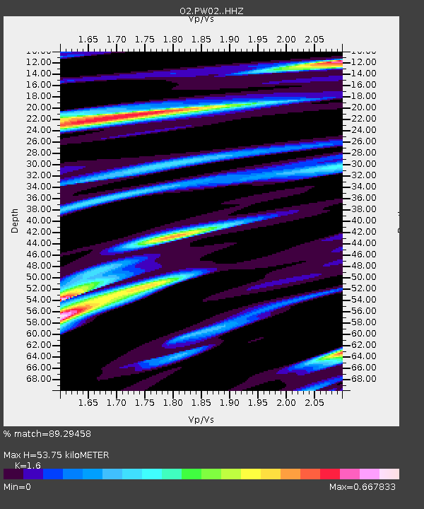
| Estimated Moho Depth: |
53.75 km |
| Estimated Crust Vp/Vs: |
1.60 |
| Assumed Crust Vp: |
6.483 km/s |
| Estimated Crust Vs: |
4.052 km/s |
| Estimated Crust Poisson's Ratio: |
0.18 |
|
| Radial Match: |
89.29458 % |
| Radial Bump: |
359 |
| Transverse Match: |
63.569267 % |
| Transverse Bump: |
400 |
| SOD ConfigId: |
20465011 |
| Insert Time: |
2020-01-07 22:22:03.348 +0000 |
| GWidth: |
2.5 |
| Max Bumps: |
400 |
| Tol: |
0.001 |
|

Signal To Noise
| Channel | StoN | STA | LTA |
| O2:PW02: :HHZ:20191224T19:10:47.22001Z | 4.7321568 | 1.286876E-6 | 2.719428E-7 |
| O2:PW02: :HHN:20191224T19:10:47.22001Z | 3.1101668 | 7.149468E-7 | 2.298741E-7 |
| O2:PW02: :HHE:20191224T19:10:47.22001Z | 3.0254233 | 6.424281E-7 | 2.1234322E-7 |
| Arrivals |
| Ps | 5.4 SECOND |
| PpPs | 20 SECOND |
| PsPs/PpSs | 25 SECOND |


