You are here: Home > Network List > UU - University of Utah Regional Network Stations List
> Station HMU Henry Mountain, UT, USA > Earthquake Result Viewer
HMU Henry Mountain, UT, USA - Earthquake Result Viewer
| Earthquake location: |
Colombia |
| Earthquake latitude/longitude: |
3.5/-74.0 |
| Earthquake time(UTC): |
2019/12/24 (358) 19:03:52 GMT |
| Earthquake Depth: |
11 km |
| Earthquake Magnitude: |
6.0 Mww |
| Earthquake Catalog/Contributor: |
NEIC PDE/us |
|
| Network: |
UU University of Utah Regional Network |
| Station: |
HMU Henry Mountain, UT, USA |
| Lat/Lon: |
37.94 N/110.74 W |
| Elevation: |
2430 m |
|
| Distance: |
47.9 deg |
| Az: |
320.474 deg |
| Baz: |
126.541 deg |
| Ray Param: |
0.06969078 |
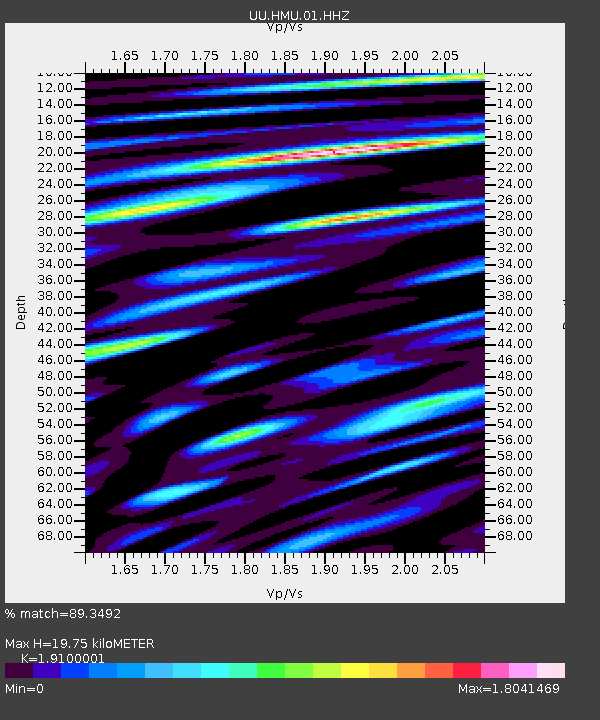
| Estimated Moho Depth: |
19.75 km |
| Estimated Crust Vp/Vs: |
1.91 |
| Assumed Crust Vp: |
6.247 km/s |
| Estimated Crust Vs: |
3.27 km/s |
| Estimated Crust Poisson's Ratio: |
0.31 |
|
| Radial Match: |
89.3492 % |
| Radial Bump: |
400 |
| Transverse Match: |
82.452354 % |
| Transverse Bump: |
400 |
| SOD ConfigId: |
20465011 |
| Insert Time: |
2020-01-07 22:29:29.655 +0000 |
| GWidth: |
2.5 |
| Max Bumps: |
400 |
| Tol: |
0.001 |
|

Signal To Noise
| Channel | StoN | STA | LTA |
| UU:HMU:01:HHZ:20191224T19:11:59.818001Z | 7.9955754 | 4.0496857E-8 | 5.064908E-9 |
| UU:HMU:01:HHN:20191224T19:11:59.818001Z | 3.9436603 | 1.8241645E-8 | 4.6255617E-9 |
| UU:HMU:01:HHE:20191224T19:11:59.818001Z | 10.467722 | 3.5172267E-8 | 3.3600687E-9 |
| Arrivals |
| Ps | 3.0 SECOND |
| PpPs | 8.7 SECOND |
| PsPs/PpSs | 12 SECOND |


