You are here: Home > Network List > MN - MEDNET Project Stations List
> Station CII Isernia, Italy > Earthquake Result Viewer
CII Isernia, Italy - Earthquake Result Viewer
*The percent match for this event was below the threshold and hence no stack was calculated.
| Earthquake location: |
Kuril Islands |
| Earthquake latitude/longitude: |
45.1/151.2 |
| Earthquake time(UTC): |
1996/10/02 (276) 11:24:48 GMT |
| Earthquake Depth: |
33 km |
| Earthquake Magnitude: |
6.1 MB, 5.4 MS, 6.0 UNKNOWN, 6.0 MW |
| Earthquake Catalog/Contributor: |
WHDF/NEIC |
|
| Network: |
MN MEDNET Project |
| Station: |
CII Isernia, Italy |
| Lat/Lon: |
41.72 N/14.31 E |
| Elevation: |
910 m |
|
| Distance: |
85.3 deg |
| Az: |
329.099 deg |
| Baz: |
29.052 deg |
| Ray Param: |
$rayparam |
*The percent match for this event was below the threshold and hence was not used in the summary stack. |
|
| Radial Match: |
53.45127 % |
| Radial Bump: |
400 |
| Transverse Match: |
64.71576 % |
| Transverse Bump: |
400 |
| SOD ConfigId: |
4480 |
| Insert Time: |
2010-03-08 16:59:08.331 +0000 |
| GWidth: |
2.5 |
| Max Bumps: |
400 |
| Tol: |
0.001 |
|
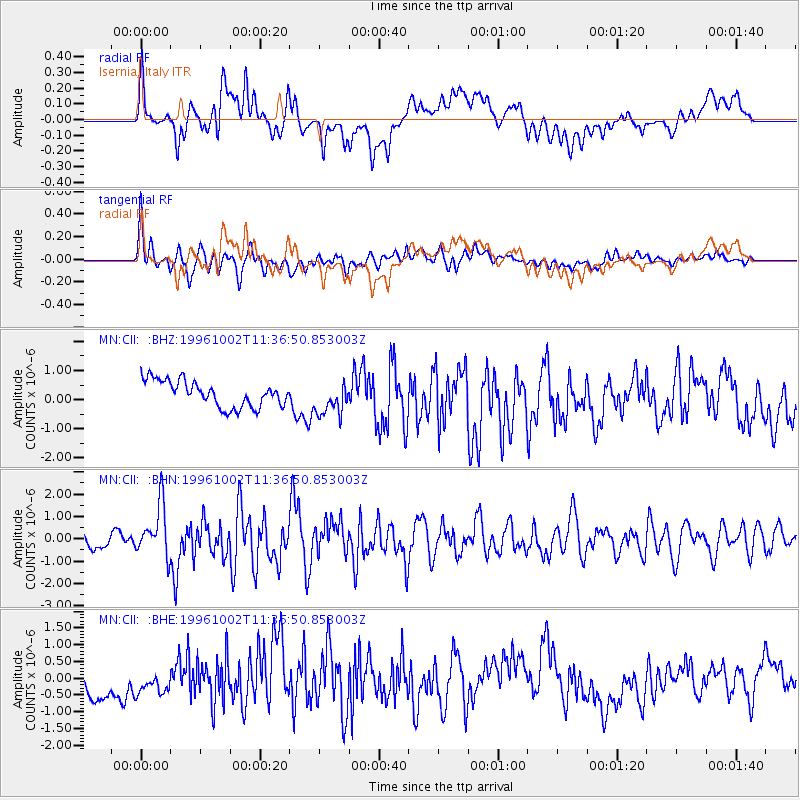
Signal To Noise
| Channel | StoN | STA | LTA |
| MN:CII: :BHN:19961002T11:36:50.853003Z | 4.7446957 | 1.1604392E-6 | 2.4457609E-7 |
| MN:CII: :BHE:19961002T11:36:50.853003Z | 0.8963808 | 5.3816086E-7 | 6.003708E-7 |
| MN:CII: :BHZ:19961002T11:36:50.853003Z | 1.2529137 | 5.579188E-7 | 4.4529705E-7 |
| Arrivals |
| Ps | |
| PpPs | |
| PsPs/PpSs | |


